Urbanisation in Asansol
A Study in Spatial Economics
Dr. Mousumi Ghosh
Dedicated
To
My Mother
ILA GHOSE DASTIDAR
This post has been divided into five parts:
Foreword
Formation of urban areas is surely advancement in human civilization. From time immemorial, urban centres emerged as mainly as seats of power. But there were other functionalities also, as for example, pilgrimage and seats of learning, trading centres, ports, martial establishments and so on. Sometimes, these functionalities co-existed, sometimes the town was mono-functional. But the formation of urban area implied creation of surplus in the agricultural sector, so that the people in other occupations could survive with food. Not only that the surplus generated was also utilized to construct the built-up space. And as an urban centre is bounded, the place becomes a place for interaction between capital and land. The nature of process of circulation of capital ultimately framed the town and the city.
The Industrial Revolution in England in the eighteenth century changed the nature of urban areas. They transformed into centres of production from centres of consumption only. The large factories were born to take advantage of the ‘power’, absolutely essential to run the mechanised production process. Three other types of urban production process emerged giving birth to ‘mining’, ‘plantation’ and ‘rail’ towns. As understood, the first one came into being where the natural resource was under the earth and modern methods were used for mass production. The second took advantage of the natural production conditions and large plantations of cash crops (rubber etc.) and beverages (tea, coffee etc.) came up and along with their processing centres, urban centres were born. The third came up with advent and spread of railroads. Rail stations, junctions and factories related to railways gave birth to rail towns. The colonial powers brought modern urbanisation in India and all these three productive urban areas in India. Asansol combined the first and the third together. Coalmining started in Raniganj in 1840s and the first train in eastern India ran from Howrah to Raniganj in 1850s. But the availability of land led to the construction of rail junction in Asansol and the area started to grow. The first steel factories of the country were also constructed here. Within five decades, it became an important urban area in the western part of Bengal. The formation and functioning of Damodar Valley Corporation aided the growth of the area with less exposure to vulnerability of nature and easy availability of power. The post-independence era saw the development of the region in different way in two phases. The first is the planned regime with nationalisation of the coal mines, Freight Equalization Policy, creation of the steel city (Durgapur). The second phase came with liberalisation in 1991. The disinvestment coupled with uncontrolled excavation brought in environmental degradation.
Whenever, we talk of a town/city we look at the history, may be sometimes geography but forget the economics, the driving force. A city survives through its economic functionality. Mousumi Ghosh, in her research work on Asansol, tried to combine space and economy for tracing the growth and sustenance of Asansol. She has described its emergence in the colonial period, its growth and the influence it had on the surrounding region. She has traced the ups and downs of the city looking at its democracy, built-up environment, transportation pattern and other important decisive factors. She did not stop with secondary data and information. She used her connection with Asansol (as a professor in local college) as a ‘participant observer’ of the changes in the last two decades. This type of study, though not uncommon in other parts of the world, is pioneering in India.
A research work of this unique type should meet wider set of readers and I am happy, it is finally coming up as a book entitled Urbanisation In Asansol: A study In Spatial Economics . I sincerely hope that it will be appreciated by academics interested in urban studies.
Kolkata Mahalaya Chatterjee
July, 2015-07-21 Director,
Centre for Urban Economic Studies,
Calcutta University
PREFACE
The present study in the urbanisation of Asansol was done during the years 2007-2010. Change is the category of life. The city of Asansol has also changed quite a lot since 2010. I hope that this humble study in urbanisation might be of some help to those who are seriously concerned with the transformation of villages into towns and towns into cities.
The foreword written by Dr. Mahalaya Chatterjee, an economist par excellence and her fresh ideas on urbanization enshrined in the same seems to have enhanced the significance of this present book.
Om Tat Sat
Mousumi Ghosh
C O N T E N T S
Chapters
- Introduction
- Theories of Urban and Regional Growth- A Framework
- A Historical Perspective of Asansol and its Surrounding Mining Region
- Urbanisation in Asansol Region during 1951-2001
- Spatial and Economic Changes in Asansol City, 1951-2001
- Conclusion
Bibliography
Chapter 1
Introduction
1.1 The Economics of Urban Space
In any human habitation, there occur interactions between space and economy. The ways in which people use space sometimes result in certain built spaces being permanently devoted to particular uses, while certain other may experience a variety of uses at different times. Each activity in space thus means that during the time it is occupied in a way, it cannot be occupied by any other. Space is thus like any scarce commodity and every human use of space has economic implications.
To assess the importance of these spatial and economic interactions, we need to know the spatial requirements of various activities in terms of their locations. It is specially relevant for an urban area. An urban area is defined as an area with a relatively high population density in comparison to that in a rural area. This definition accommodates urban areas of vastly different size ranging from a small town to a very large city. Unlike in the villages, there is little or no trace of primary activities in a city. It is the hub of various secondary and tertiary activities. These activities can be carried out more easily or profitably in one space than in other. So in every town, almost all pieces of land or in other words the physical space is a built space. Its utilization depends on one or more decisions. Thus any town or a city is unique in its built space. However, if the decisions had been taken place at different times and if different groups of people had been party to such decisions, the spatial and economic interaction pattern might become different.
For example, earlier a city used to be the store house for surplus agricultural produces of the villages around. The farmers require well protected storage space for their surplus food. Thus storage and protection of surplus agricultural product will demand defence services. This activity is subject to economies of scale. A single fortified storage facility is less costly to the producers than that of a large number of small individual storage space. A specialised labour force connected with the different activities of storage and protection of surplus agricultural product gets concentrated there. Population densities will thus increase generating the development of a city. Thus the first cities provided defensive services. However behind the development of the first cities, a number of factors operated simultaneously.
According to Mumford (1961) for instance, the development of first cities coincided with the development of large-scale religions. Large temples at central locations replaced the small worship places in homes and rural areas. Production of built space like temple or a church can produce economic activity. People throng there from surrounding villages. To that end they spend on transport, food and shelter. Moreover, when villagers come to a city for religious purpose, not only inns are there to give shelter to the pilgrims, but also large fairs take place. Increase in population densities thus transforms the area to a city. Thus economies of scale in religious activities caused the development of a city. When the surplus created from these economic activities is spent, other economic activities are created attracting more people in the cities. Thus the first cities provided religious services and defence.
Subsequently, the cities emerged as the unifying and predominant form of political organisation. They became the early administrative centres controlled by kin- related lineages and clans. Gradually some of them turned into larger political units with chieftains and small kingdoms due to increase in demand for traded goods. This also led to warfare and the evolution of fortified walled cities. The first monarchy developed by uniting some of these administrative districts under a single umbrella. The centralization of power helped in the centralization of administrative and military functions there. Moreover, consolidation of power helped in liberating different local trade barriers and thus trade increased. Search for new markets encouraged new sea routes. Mercantile cities developed along these trade routes. Thus whatever be the initial impetus, ultimately economic forces play a major role in the transformation of a space.
However, despite the evolution of many cities in the medieval period, it is mainly the industrial revolution of the nineteenth century that resulted in rapid urbanisation of the last two centuries. The industrial revolution brought innovations in manufacturing and transportation sectors. Manual production was replaced by mechanised one. Many of these new production processes require interchangeable parts and the service of a common pool of specialized labour services. This created forward and backward linkages generating the advantages of agglomeration. Moreover, the common need of power facilities to operate them caused centralization of production and employment. The exigency of steam power caused the expansion of the extractive industry like coal. Use of iron instead of wood for making the new machines also caused the expansion of steel industries. All these developments in manufacturing helped in the evolution of factory cities. Moreover, innovations in transportation like steamship and railways and afterwards automobile also helped in industrialization and increased the benefits of centralized production. Consequently, the location of a junction railway station nearby decreased the cost of delivering goods and thus production became more centralized and industrial cities evolved.
The relative cost of industrial goods decreased because transportation costs decreased and scale economies in production were realised. There are more employment opportunities in cities due to the presence of comparative advantage, scale economies in transportation, internal scale economies and agglomerative economies.
As cities developed due to employment generated by the industries, the location choices of the industries play a role in their location. A local spatial resource oriented industry has relatively high transport costs for its input, so it locates near its input source. A market- oriented one has relatively high transport costs for its output, so it locates near its market. The nature of locational orientation thus resulted in the growth of many cities.
Asansol city in the western part of the Barddhaman district in West Bengal, for example, is a model of a city which owes its existence to a spatially concentrated mineral deposit, coal. It is the nodal centre of the vast Raniganj coal belt. Coal is the chief resource which initiated the process of capital circulation in this region. Consequently, Asansol is an important railway junction station in eastern India connecting it to the northern and south eastern part of the country. Very few cities in India and no other places in West Bengal have such juxtaposition of natural and built space like collieries, agricultural lands, villages as well as very important rail and road networks, junction rail station, basic and heavy industries and different ancillary industries and a bustling trade and transport centre. Thus Asansol seems to be the space where the factors like comparative advantage, scale economies in transportation, and agglomerative economies played a positive role in its urbanisation process. Moreover public sector industrialisation policy during the early five year plan periods in the post independence period played a considerable role here, generating new hopes of urban development.
The main purpose of our study is to examine the interactions between spatial and economic changes in and around the Asansol city during the post independence period, with a backdrop of the study on the evolution of the town during colonial period.
The rest of the chapter is divided into following sections. Section 1.2 discusses the objective of the study followed by a brief review of the existing literatures. Section 1.3 is a description of the Asansol city. Section 1.4 discusses the plan of the work. Section 1.5 mentions the data sources and section 1.6 is the concluding one. Since our main reference is Census, we have discussed some standard definitions of Census of India 2001 and earlier periods related to our study in the appendix.
1.2 The Objective of the Study
The present work aims to incorporate both space and time to study the interaction process between economic forces and spatial changes in and around the Asansol city.
Specifically the objectives are:
1) To study Asansol both from the regional and the intra city perspective in terms of temporal and spatial changes.
2) To understand the historical process of this coal belt, we have started from the colonial period.
3) To evaluate how India’s public sector industrialisation policy in the post independence period from 1951 to 2001 influenced the flow and circulation mechanism of production, distribution and exchange in this mining based industrial and trade belt.
Consequently, the whole period is divided into
i) Pre-Nationalisation period-1951-71,
ii) Post-Nationalisation period - 1971-1991 and
iii) Post-Liberalisation period- 1991-2001.
- To analyse the intra city location pattern by ward level study to determine the nature of land use in Asansol.
There has been a considerable volume of useful studies available for understanding the various facets of the process of urbanisation. There are also some socio-economic surveys on towns as well.
Among the town studies of West Bengal from the viewpoint of urban economics, the study of Bolpur (Mukherjee, 1972) is the oldest one. It analysed some of the economic and social aspects of the growth pattern of an area of Birbhum district in West Bengal, which was predominantly agricultural one.
The study based on a collection of research papers on urbanization, migration and rural change of West Bengal (Dasgupta (ed), 1988) emphasised on the urbanization patterns, trends and processes in different cities and towns of West Bengal. The study mainly focussed on the links between urban development and rural changes. It included a number of studies on towns and cities of different sizes and characters, covering a wide spectrum of disciplines from economics, sociology, anthropology to urban planning and demography. Among them, the analysis of the growth of small and medium towns in West Bengal (Giri, 1988) and a case study of Durgapur (Basak, 1988) are immensely valuable for our study. The first one contributed significantly to develop our knowledge regarding the industrial-urban development of Asansol and Durgapur subdivision of Burdwan district based on mining and mining based industries during the 1951-1981, which is part of our study period, Basak’s paper contributed notably to understand the nature of growth process in steel town Durgapur and its spatial impact on the surrounding region. As Durgapur is a significant city in the mining based industrial region of Asansol, this work has got an important context in our study.
Further, her extensive study of the five Indian steel towns namely Jamshedpur, Durgapur, Bhilai, Rourkela and Bokaro covering the period 1961-1991 (Basak, 2000) also examined the nature, direction and degree of interaction of the steel towns with the surrounding region.
Likewise, the study of mining and urbanization in the Raniganj coal belt by Lahiri- Dutt (2001) analysed how in the post independence years, the huge amounts of public capital investment in natural resource extraction and industries generated urban growth and a complete transformation of the physical and cultural landscape over a short period of time. In her research from the view point of an urban geographer, she studied the growth of mining towns of Raniganj coal belt and analysed the implicit linkages between coal mining and urbanization in the Raniganj coal belt. She has taken into account the occupational changes of the moujas in the vicinity of Raniganj. It is commendable work no doubt, but it was an old study and for a shorter period .1991 census data was the latest one used in the study. Further, the issue of how the discovery of coal mines and their activation generated multiple kinds of economic activities resulting in the spatial expansion where the coal mines served as the germ cell was not within the ambit of her research area.
There are some cross-sectional studies where Asansol region figures. They concentrated on some specific issues. For instance, the study on the ancillary industries in Asansol- Durgapur region (Macdougall, 1965) was an in-depth one. The account of these industries provided us necessary information about the pattern of industrialisation here during the 60’s.
There have been some considerable research works by urban geographers concentrating on the spatial aspect of the urbanisation process of Asansol- Durgapur region like the evolution of Asansol-Durgapur industrial complex (Chakraborti, 1998), spatio-temporal growth of industrial centres and its impact on urbanization in Asansol- Durgapur area (Guha, 1996) and the impact of environmental problem on land use of Ajoy Damodar inter-fluve (Dutta, 2003). They focussed mainly on the regional aspects. Asansol Planning Organisation and Asansol Durgapur Development Authority published some socio- economic reports. The subject, spatial and economic changes in an urban area thus can be approached in various ways as urban economics seems sometimes to be an all embracing one (Evans, 1985). A considerable volume of studies on this region focussing mainly on the industrialisation aspect therefore demonstrate the economic importance of Asansol city, the nerve centre of the Asansol- Raniganj- Durgapur region as a subject of case study.
Among the significant urban studies of other Indian towns and cities, the study on Chandigarh (Evenson, 1966) concentrated mainly on the pattern of architecture and planning of the city. The study of Bareilly (Lal, 1987) focused on the spatial growth of the city from the viewpoint of an urban geographer. The past literatures give us an idea that process of spatial and economic changes in an urban area is multi- disciplinary. Thus all these cross sectional studies contributed to understand the different facets of urbanisation.
However, a comprehensive study regarding spatial and economic changes in a city thus incorporating both space and time has remained an unexplored area to the best of our knowledge. To fill in this gap, the present work aims to study spatial changes in Asansol in relation with the economic changes during 1951-2001. Moreover, it is particularly relevant and significant to assess the industrial-urban development of West Bengal as in the post-independence period West Bengal experienced rapid urbanisation in its Asansol- Raniganj- Durgapur mining based industrial region. We have chosen 1951- 2001 as our datum line for this reason.
1.3 Asansol City - A Mosaic
Barddhaman district in West Bengal as it is now is shaped like a hammer. The two cities of the district Asansol and Durgapur is its handle. The eastern part is one of the most productive agricultural regions in West Bengal. The western part of Barddhaman district, the mining based Asansol industrial region is an integration of a number of cities and small towns starting from Durgapur in the east and stretching westward to Raniganj, Asansol, Burnpur, Kulti, Neamatpur, Rupnarayanpur and Chittaranjan of which Asansol is the nucleus. Among the notable ones, there are two Class 1 cities Asansol and Durgapur governed by Municipal Corporations, three Class I municipal towns Raniganj, Kulti and Jamuria and two class III census towns Chittaranjan and Hindusthan Cables Town. They differ in area, Durgapur being the largest and Hindusthan Cables Town being the smallest among them but each of them has individual strength. Asansol is the hub of trade and commerce. Raniganj is the storehouse of coal, and Jamuria has also many coal mines. It is also becoming an industrial hub. The urban areas created in the colonial period are Asansol, Burnpur, Raniganj and Kulti. The towns created for fulfilling the needs of heavy industrialization objectives of the Indian Government in some backward areas of Asansol region are Chittaranjan, Durgapur (1961), Jamuria (1961) and Hindusthan Cables Town- Rupnarayanpur (1971). A major industrial- urban cluster grew up around the city of Asansol since it is a provider of rail junction and road network, coal and steel and a trade and commerce hub. Durgapur is also a large industrial city and produces basic metal, non- metal and chemical goods. Raniganj, Jamuria are the suppliers of coal. Chittaranjan produces locomotives. This locomotive industry acts as forward linkage for the utilization of steel produced in this industrial sub division. Hindusthan Cables is the manufacture of telephone cables. The locational decision might be the advantages of procuring raw materials from the diversified industrial base in the region, the transport and the communication facilities and a developing intra regional market. There are a number of small towns at the base of the pyramid with very high rate of birth and death of small mining towns in the region.
The city Asansol has an urban area of 127.87 sq km. The population of Asansol is 475,439. Population density is 3718 per sq km. (Barddhaman District Census Handbook, 2001). The urban local body of the city, the Asansol Municipal Corporation of today was formed in 1994 by amalgamating Asansol municipality, Asansol blocks and the Burnpur Notified Area.
The area of the Raniganj coal field is 1530 square kilometres (Bandyopadhyay, 2005). The Eastern Coalfield Limited has hundred and seven operating mines; majority of them are in and around Asansol. There are coal mines within the corporation boundary. Collieries are mainly located in the eastern part. Moreover, it is an important division of the Eastern Railways. It is along the axial routes connecting the metropolis like Kolkata and Delhi. The grand chord line (Raniganj to Dhanbad) and main line (Sitarampur to Chittaranjan) of the eastern railway bifurcates at Sitarampur junction, a little to the west of Asansol. In addition, the branch of the south eastern railway connects the city with other parts of the country through Adra and then to Jamshedpur via Purulia and Kharagpur via Bankura. A branch line connects Andal with Sainthia via Sahebganj loop. A large number of super fast express trains, passenger trains and goods trains pass through Asansol daily. The Map 1.1 below shows some of these spatial links.
Map 1.1
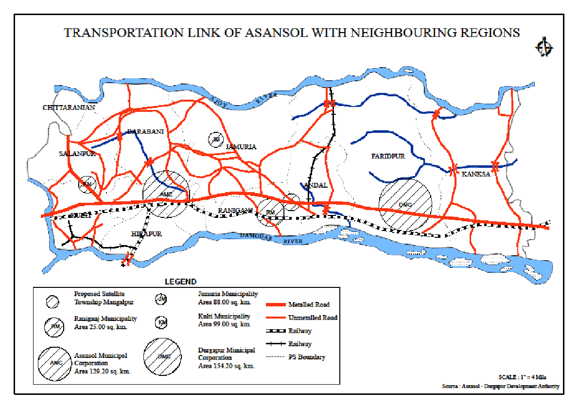
The spatial advantage of Asansol is not restricted to rail transport only. Asansol has an excellent strategic location as it is situated in the border region of Bengal and Jharkhand. The city being the centre of trade and commerce is well linked with other regions. It is also a market for steel since there are railway engine, pipe and wagon making factories here. Grand Trunk road (NH-2) is positioned in the east-west direction parallel to the eastern rail line. It is the main arterial road of this region. NH-Bypass has been constructed in the northern periphery of Asansol Urban Area. Most of the urban settlements are located along this transport corridor. There is high centralization of multiple activities of retail and whole sale trade on GT Road.
The secondary and tertiary sectors, the development of built infrastructures like good mass transit system, construction of basic and heavy industries like Kulti Iron Works, Burnpur Iron and Steel Factory, ancillary sectors, wholesale as well as retail trade and commerce contributed to a large extent in the city’s development.
The type of built infrastructure is a signifier of the economic activities of the city. The industries occupy 2750.36 acres of land of this city (An Introspection, Asansol Municipal Corporation, 2001). They are mainly concentrated in the north western part. The largest employers in this city are the two public sector units, namely Eastern Coalfields Limited and IISCO Steel Plant of Steel Authority of India Ltd. Other major industries are both public and private sector units of various size and age producing a variety of products like sponge iron, industrial gas, refractory items etc.
The land use pattern of a city is a proof of the inter-linkage between space and economy. Each and every city has unique land use pattern which specifies how the space has been created by the economy.
Mining occupies 675 acres of surface land in the city. Damra, Ajay Second, Khusdanga, Girmint, Kakardanga, C M Ghusik, Ghusik no 3, Mohisila Hattola, Narsamudra, Ghusik, and K.D.Sim are the collieries within the corporation area. Railways occupy 1630 acres of the total land of the city. Industries occupy 2750.36 acres. Industries are mainly concentrated in the north western part. Agriculture occupies 7943.52 acres. Crops are harvested mainly during the rainy season. For other urban functionaries’ 10256.12 acres are reserved. Total vacant land is 82.45 acres. (An Introspection, Asansol Municipal Corporation, 2001).There is lack of adequate information regarding the underground land use of this mining based industrial city. The pie chart- figure 1.1 below shows the percentages of the surface land utilisation pattern of this city.
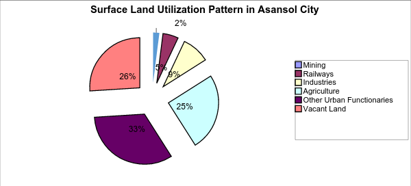
Fig 1.1
Fig 1.1
Source: An Introspection (2001), Asansol Municipal Corporation, Asansol
1.4 Plan of the Work
The plan of the work is as follows: after this introductory chapter, in chapter 2 a conceptual framework has been developed making a synthesis of the different theories of urban spatial structure, which we have mentioned in this introductory chapter. Chapter 3 is on the historical perspective of the development of Asansol and its surrounding region and analyses the process of space- economy interaction. This region became famous in the colonial regime after the discovery of coal in its underground and its commercial use widened. Henceforth, the history of this region became synonymous with the history of coal mines, transport, industries and trade. Chapter 4 is a study of the urbanisation in Asansol region during the post independence period 1951-2001. Here the role of national economic policies have been analysed in detail. The region has many types of urban space at present like Municipal Corporations, Municipalities, and Census Towns due to its mining, industrial and trading base. To get an overall view of this region, we are taking into account here the following seven urban spaces which function as nodal points in the Asansol region under study. They are Asansol, Durgapur, Raniganj, Kulti, Jamuria, Chittaranjan and Hindusthan Cable Town Rupnarayanpur. Moreover, this chapter studies the report of the primary survey in the three coal mines in this region in 2007 emphasizing the socio- economic conditions of the employees of Eastern Coalfield Limited at present. Chapter 5 concentrates on how the spatial and economic changes shaped the settlement pattern in Asansol during 1951-2001. It is an intensive study of the wards of Asansol Municipal Corporation followed by statistical analysis. Finally, Chapter 6 gives a summary of the findings and the concluding observations.
1.5 The Data Base
The study is based mainly on secondary data substantiated by primary data as per requirement.
The Secondary data sources consist of:
1-i) Primary Census Abstract of Barddhaman district of different years
1-ii) Reports of Asansol Durgapur Development Authority
1-iii) Reports of Asansol Municipal Corporation
1-iv) Reports of Central Pollution Control Board, Web edition
1-v) Relevant literature and research papers on mining and urbanization
1-vi) Industrial statistics (especially small industries sector) from the Sub District Industries Centre, Durgapur
1-vii) Website of Coal India Limited.
1-viii) Other web resources.
The Primary data sources consist of:
2-i) Responses of interviewees to a pre scheduled questionnaire collected from a primary survey jointly carried out by the Centre for Urban Economic Studies University of Calcutta and Australian National University among the employees of ECL in the three collieries of Raniganj coal belt in 2007.
2-ii) Unpublished information materials gathered from the offices of the Asansol Municipal Corporation; coal mines of Eastern Coalfields Limited; Asansol Sub Divisional Mini Bus Union; Eastern Railways; West Bengal Industrial Development Corporation and United Bank of India Asansol.
2-iii) Oral history of the region and the present scenario collected from local people.
1.6 Conclusion
A study of urbanization can thus focus on transformation of space into an urban area. The study would aim to analyse how space is produced and reorganised in course of urbanization as a part of expansion of different economic activities.
Appendix to Chapter 1
1.1 Definitions and Concepts
We have used the standard definitions of Census of India 2001 for our study. We have also followed the spellings used by Census of India regarding the names of the places.
- Urban Area
In the Census of India 2001, the definition of urban area adopted is as follows: (a) All statutory places with a municipality, corporation, cantonment board or notified town area committee, etc. (b) A place satisfying the following three criteria simultaneously:
- a minimum population of 5,000;
- at least 75 per cent of male working population engaged in non-agricultural pursuits;
- a density of population of at least 400 per sq. km. (1,000 per sq. mile).
- City
Towns with population of 1, 00,000 and above are called cities.
- Urban Agglomeration
An urban agglomeration is a continuous urban spread constituting a town and its adjoining urban outgrowths (OGs) or two or more physically contiguous towns together and any adjoining urban outgrowths of such towns. Examples of OGs are railway colonies, university campuses, port areas etc., that may come up near a city or statutory town outside its statutory limits but within the revenue limits of a village or villages contiguous to the town or city.
- Slum
The slum areas broadly constitute of:
(i) All specified areas in a town or city notified as ‘Slum’ by State/Local Government and Union Territory (UT) Administration under any Act including a ‘Slum Act’.
(ii) All areas recognized as ‘Slum’ by State/Local Government and UT Administration, Housing and Slum Boards, which may have not been formally notified as slum under any act.
(iii) A compact area of at least 300 population or about 60-70 households of poorly built congested tenements, in unhygienic environment usually with inadequate infrastructure and lacking in proper sanitary and drinking water facilities.
- Household
A 'household' is usually a group of persons who normally live together and take their meals from a common kitchen unless the exigencies of work prevent any of them from doing so.
- Literates
A person aged 7 years and above who can both read and write with understanding in any language has been taken as literate.
- Work Participation Rate of Male Main Workers
Work participation rate of Total male workers x 100
male main workers = Total male population
- Household Industry
Household Industry is defined as an industry conducted by one or more members of the household at home or within the village in rural areas and only within the precincts of the house where the household lives in urban areas.
- Other Workers
All workers other than cultivators or agricultural labourers or household industry workers are 'Other Workers'.
- Sex Ratio
Sex ratio has been defined as the number of females per 1000 males in the population.
It is expressed as ‘number of females per 1000 males’.
- In-migrant
A person who crosses the boundaries of a village/town for the purpose of residing at the place of enumeration is an in-migrant.
- Out-migrant
If a person moves out from the place of enumeration (village/town) to another politically defined area (village/town) for usual residence, he or she is termed as an out-migrant.
- Census of India Definition of Urban Areas From 1951-1991 Census - A Comparative Study of Definitions in the following Appendix Table 1.1
Appendix Table 1.1
Census of India Definition of Urban Areas From 1951-1991 Census - A Comparative Study
sl
|
1951
|
1961
|
1971
|
1981
|
1991
|
1
|
Municipal Corporation
|
Municipal Corporation
|
Municipal Corporation
|
Municipal Corporation
|
Municipal Corporation
|
2
|
Municipal Area
|
Municipal Area
|
Municipal Area
|
Municipal Area
|
Municipal Area
|
3
|
Town Area Committee
|
Town Committee
|
Town Committee
|
Town Committee
|
Town Committee
|
4
|
Civil Lines not included within municipal limits
|
Notified Area Committee
|
Notified Area Committee
|
Notified Area Committee
|
Notified Area Committee
|
5
|
Cantonment Board
|
Cantonment
|
Cantonment
|
Cantonment
|
Cantonment
|
6
|
Test prescribed for distinguishing towns from villages were not identical for all the states.
|
Selected places with:
|
All other places satisfying the following criteria
|
All other places satisfying the following criteria
|
All other places satisfying the following criteria
|
a) density not less than 1000 per square mile
|
i) a minimum population of 5000
|
i) a minimum population of 5000
|
i) a minimum population of 5000
| ||
b)population of 5000
|
ii) at least 75% of the male working pop in non agricultural;
|
ii) at least 75% of the male working pop in non agricultural;
|
ii) at least 75% of the male
working pop in non agricultural;
| ||
c)three – fourth of the working pop working outside agriculture
|
iii) density of pop at least 400 per sq km
|
iii) density of pop at least 400 per sq km
|
iii) density of pop at least 400 per sq km
| ||
d) or any other place, which according to the Superintendent of the state possesses urban characteristics or amenities.
|
The Directors discretion in respect of some marginal cases in consultation with the state government to some places that had other distinct urban characteristics and exclude undeserving cases
|
The Directors discretion in respect of some marginal cases in consultation with the state government to some places that had other distinct urban characteristics and exclude undeserving
cases
|
The Directors discretion in respect of some marginal cases in consultation with the state government to some places that had other distinct urban characteristics and exclude undeserving
cases
|
Source: Course Material Module 1 (2010), Urbanisation and Urban Development, CUES, University of Calcutta, Kolkata
Settlements declared as urban on the basis of second and third approach are called census towns. In Census 2001, the discretionary approach was dropped and thus many census towns that did not satisfy one of the three above criteria were declassified.
Chapter 2
Theories of Urban and Regional Growth- a Framework
2.1 Introduction
The central objective of this study is to examine interaction between spatial and economic changes in the process of urbanisation in Asansol region with a focus on Asansol city. The conception of space is essential for analysing the growth process of a central foundation of the present day economy, the city. Organised space has been created by men impelled by their multiple demands. Demand or human want is at the root of all economic activities. Hence man’s creation of organised space is an economic activity. As soon as they learnt the art of agriculture, they settled in a particular place and thus structured space. The resources of that space further influenced their economic activities. Consequently urban structures can start off from a spatially concentrated endowment. This chapter analyses this interaction mechanism from different perspectives. Accordingly, the rest of the chapter has been organised as follows:
- Capital circulation and creation of urban space
- The formation of an urban system within a region
- The intra city spatial transformation
- Conclusion
Urbanisation is a process in which the economic activities and the built space changes and there is a lot of interaction between these changes. We are trying to construct an analytical framework by combining different theories of urban spatial structure. In the process of urbanisation, the sectoral composition of urban economy and location of economic activities changes accordingly. While in the rural areas the activities are farm-based, in urban areas non-farm activities predominate. Further these non-farm activities, like manufacturing, trade and other tertiary activities are located in a highly concentrated manner over space. This generates concentrated demand for not only housing but also various other facilities including that of mobility. The structure of space changes to accommodate such demand – thus transport facilities, housing, and water supply needs to be organised properly within the built space. Once such organisation of space takes place, the spatial unit derives some comparative advantage compared to the other spatial units that have not gone through similar type of changes. This comparative advantage is reflected in the profitability of the economic activities located in that spatial unit and further economic investment are made.
2.2 Capital circulation and Creation of Urban Space
This interaction of space and economic changes can be understood at a different level in term of circulation of surplus and capital formation. While private capital is generally invested in manufacturing and other activities generating profit or further surplus, such process can be sustained only when favourable situation exist for investment. Such favourable situation includes the right kind of spatial set up. Therefore investment needs to be made for changing the space and creating public goods which is commonly available to all or most. Spatial changes mostly being in the nature of public good, investment for spatial changes is in most cases to be made by the state.
Products need new markets for their distribution. The scale of production determines the space of distribution. It can be within locality or beyond it. When the scale of production enlarges, products are sold outside the local markets and one needs a proper infrastructure. So a well developed transport network preferably funded by the government is needed to connect the space of production to the different centres of consumption.
The process of spatial and economic interaction occurs as an outcome of different interconnected factors. The criterion of labour power is a major one. Labour is a factor of production which requires space for reproducing its energy needed for daily production. It has a definite life cycle. It has to distribute its work and leisure time among the available twenty fours hours per day. Labour power is composed of individual labour units. The surplus creation process depends on the optimum use of labour power and in this regard the distance of workplace from the residence is an important criterion. The time and cost of commuting can affect the rate of production so built spaces are to be constructed in the form of housing facilities and improved transport and communication network to get uninterrupted flow of labour supply.
A right kind of spatial set up attracts in-migration and the growth of population creates new demands and thus new arena for capital circulation to keep these people grounded in the specific space. The sources of effective demand are mainly the workers’ purchase of wage goods, the demand for comforts and luxuries of the salaried class and the procurement of intermediate products and the investment goods by the owners of capital. The diversity of consumers demand attracts capital flow as there are scopes of product diversifications. Capital circulation results in the formation of new consumption spaces progressively.
Again, the turn over time of capital depends on the efficiency of labour power. Thus it needs investment in skills which is a long term process. The government here also has a prime role, especially in the initial period as skill development set up is not a quick profit giving sector. The entire process involves more restructuring of physical space over time.
The organisation of a space also depends on the composition pattern of manpower needed for production of goods and services. The nature of built space is not similar in an economy where majority population belong to white-collared salaried job and in an economy based on activities like mining where a considerable people belong to the blue- collared wage labour class. Capital will flow in the first case not only for education and health but also for the construction of gentrified consumption spaces for entertainment activities. These different types of built space act as the necessary base for market exchange and carrying the mechanism of surplus creation. So capital accumulation and urbanisation are interconnected (Harvey, 1989).
The spatial economics of a city can be studied from two standpoints in the following sections. The first one analyses it by considering the formation of an urban system within a region and the second one is a study of the intra city spatial dynamics.
2.3 The Formation of an Urban System within a Region
Urbanisation process at the regional level can be analysed looking at the growth of the urban centres and the resulting organisation of the space in a regional scale. The urbanisation pattern of city is interconnected with the formation of an urban system within a region. However the factors which contribute to an evolution of a city may vary from that of the region. There are two well known theories linked to the process of urbanisation at the regional level - growth pole and urban hierarchy which are reviewed in the subsections below.
2.3.1 Growth Pole
A Growth pole is a set of industries capable of generating dynamic growth in the economy, and strongly interrelated to each other via input- output linkages around a leading industry (Richardson, 1978). The clustering of these industries can create growth centre. The growth centre is said to be a town or a group of towns in which new investment in industry and infrastructure is concentrated in the expectation that its development will stimulate growth in the surrounding region (Evans, 1985). Growth centres are usually selected by the government as a structure for integrating industrial policy, physical planning and inter and intra regional economic planning. It is based on domination and disequilibrium or in other words uneven development. The project begins with construction of a leading industry as a growth pole in an underdeveloped virgin region. Creation of a growth pole thus transforms a virgin and usually agricultural area into a built space having urban infrastructural facilities, provision of needed public and social services and amenities for labour. This industry will then draw a set of industries in the area. The spatial cluster of industries will create forward and backward linkages among them.
So the Growth pole concept anticipates a sizeable spatial spill over and multiplier effects on other sectors of the economy and developing the hinterlands over time. However the development of growth pole and the growth centre creates both positive and negative impacts on its hinterlands. The negative impact is called the ‘backwash effect’ and the positive one is called ‘spread’ effect. Backwash effect pulls the resources from hinterland to poles. It occurs through relocation of pre existing industries, resettlement of labour especially the skilled ones and reallocation of savings from the hinterland to fast growing centres. The spread or dispersion effect takes place with the transmission of innovation, investments and different attitudes to growth through the hinterlands. So the anticipation is that it helps in the development of the hinterland.
However, the backwash effects are stronger than the spread effects in the early years of production and thus the development of growth centre initially means decline of the rate of growth of its hinterland. Figure 2.1 shows how spread and backwash effects take place over time (Richardson, 1978).
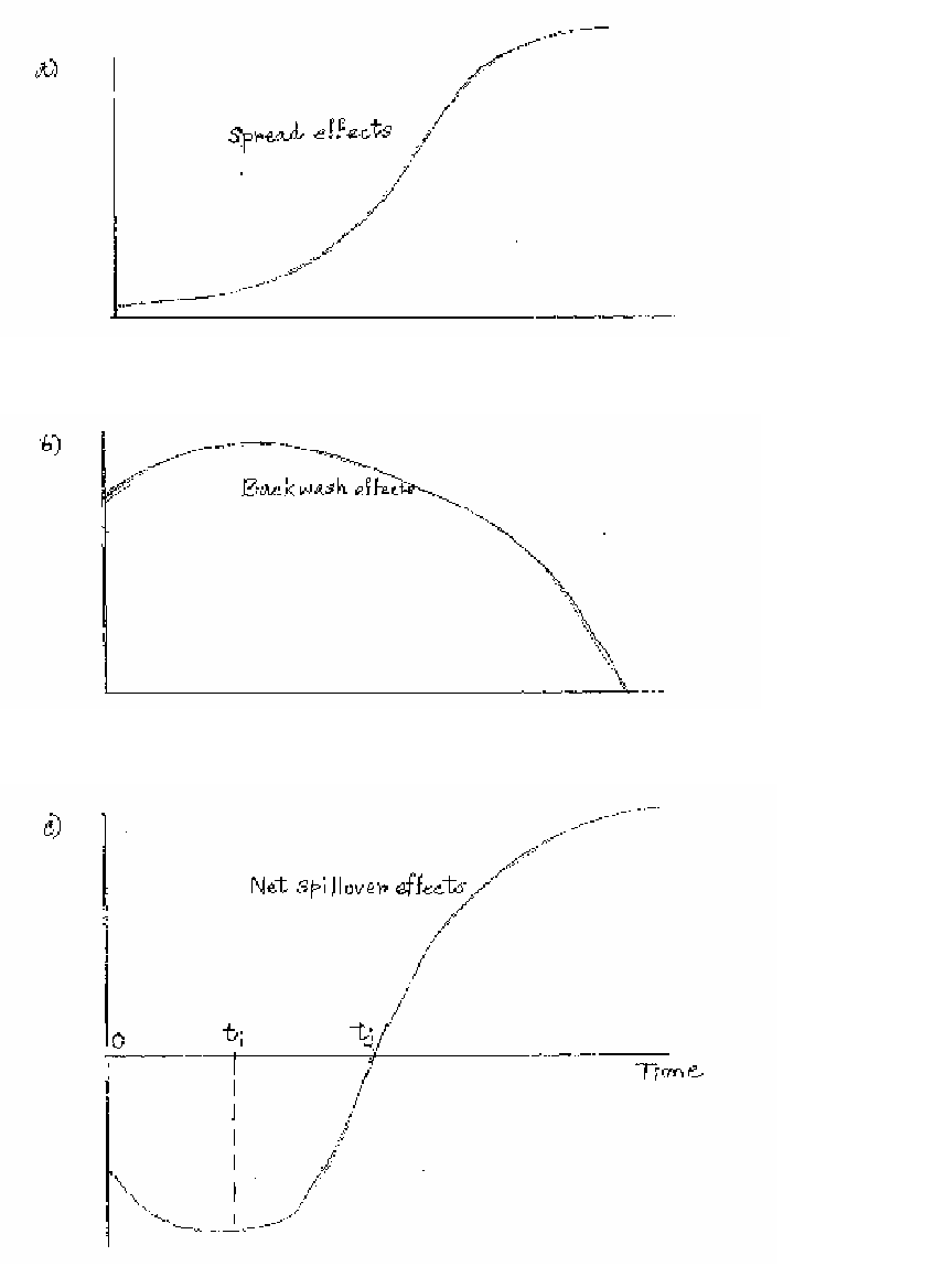 Fig 2.1 Spread and Backwash Effects over Time
Source: Richardson, H (1978). Regional and Urban Economics, Harmondsworth, Penguin Books
Spread effect is represented as a logistic function of time (Figure 2.1a). It has three phases. At the outset it has a slow beginning, then it gathers momentum and finally the saturation stage is reached when it slows down. The whole process takes a considerably long period of time. Backwash effect is represented as a quadratic function (Figure 2.1b). Backwash effects are high at the outset as resources are attracted towards the pole; they reach the peak after some years due to gradual build- up in agglomeration economies. Finally backwash effects become weaker over time as some of these hinterland resources are non replenish-able. The net spill-over function (Figure 2.1c) shows the vertical difference of backwash from spread effect. As backward effect is stronger than the spread effect in the early years, net spill- over function has negative values initially. After ti spread effect gathers force and backwash effect weakens. Net spill-over effect becomes positive after tj. Ultimately, net spill-over effect levels off when spread reaches saturation. The turnover time to achieve the net positive spill-over i.e. tj is a considerably long one. Thus growth poles can induce net favourable impacts in their hinterlands only in the very long run. As growth pole planning is practically a political decision, the long time span required to achieve benefit reduces the scope of earning political mileage through this strategy.
Moreover it mentions the forward and backward linkages as the cause of formation of other industries in the growth centre. But shortage of productive space in the town can shift the location of an industry to neighbouring place in the region. This is one of the main reasons for the existence of different size classes of towns and cities in a region. It also fails to determine the threshold population size for a pole. So the growth pole model fails to analyse the cause of spatial dispersion of activities in a region. It focuses mainly on the internal workings of the pole and not on the external effects of the flow of goods and people across an urban region.
2.3.2 Urban Hierarchy
Urban hierarchy in a region signifies a structure in which there are few large cities, a number of medium-sized cities, and larger numbers of smaller cities and towns (Evans, 1985).The urban centres in a region are arranged into a size hierarchy because no single city is capable of providing the various goods and services to the whole region due to constraints in economic, topographical, political and social factors. The different functional needs of the society create towns of different size classes in a region.
Central place theory dwells on the relationship between a central place- higher order place and its tributary areas- lower order places. A Central Place is a settlement which generates services for the population in the surrounding areas. Simple basic services said to be of lower order are provided by low order settlements. Specialized services of higher order are given by high order settlements. The area under the influence of a Central Place is its sphere of influence. The theory originally published by a German geographer Christaller (1933) seeks to explain the spatial arrangement, size and number of settlements. In the flat landscape of southern Germany he observed that towns of a certain size were equidistant from each other. By examining and defining the functions of the settlement structure and the size of the hinterland, he forged the pattern of settlement locations of geometrical shapes.
His model was based on some stringent assumptions such as all areas should have flat land, an evenly distributed population, evenly distributed resources and similar purchasing power of all consumers; consumers will always buy from the nearest market. Perfect competition rules there. Transportation cost is equal in all directions.
There are two basic concepts of this theory- i) threshold ii) range of goods and services. Threshold size is the population that is required for certain good or services to be generated. Range of goods or services implies the average maximum distance people will travel to purchase goods and services. The following figure 2.2 depicts these two concepts.

Fig 2.2
Source: http://www.yck2.edu.hk/onlinestudy/form6/ychui02.pdf
With the upper and the lower limits, it is possible to see how the central places are arranged in an imaginary area.
As transport is equally available in all direction, each central place will have a circular market area as shown in C (Figure 2.3).
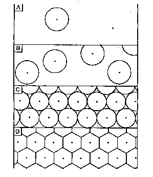
Fig 2.3
Source: http://www.yck2.edu.hk/onlinestudy/form6/ychui02.pdf
But the problem is that the circular shape of the market areas results in either un-served or over- served areas. Christaller therefore depicts the market as of hexagonal shape as shown in D. There are fewer higher order cities and towns in relation to the lower order villages and hamlets. The settlements are equidistant from each other for any given order.
In Christaller’s model, there are three different arrangements of central places according to the three principles- the marketing principle (K-3) system, the transportation principle (K-4) system and the administrative principle (K-7) system.
In the light of the marketing principle there can be many orders of settlement. First order service centre provides first order service. Similarly second order and third order service centres provide second and third order service. The different orders of settlement arrange themselves in a hierarchy (Figure 2.4).
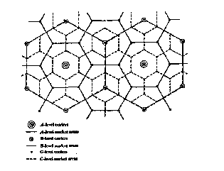
Fig 2.4
Source: http://www.yck2.edu.hk/onlinestudy/form6/ychui02.pdf
The higher is the order, the larger is the area served and the lower is the order; larger is the number of settlements. If the arrangement of the settlements is according to the principle K=3, a higher order central place is serving three of the next lower order central places.
The transport principle connects the different levels of hierarchy. Thus the central places would be lined up on straight traffic routes which radiate from the central point. The lower order centres are located at the midpoint of each side of the hexagon .The following figure 2.5 shows that the transport principle produces a hierarchy organized in a K=4 arrangement in which central places are nested according to the rule of four.

Fig 2.5
Source: http://www.yck2.edu.hk/onlinestudy/form6/ychui02.pdf
Moreover, cities are not only the centres of production but they are also the centres of administration. Size of towns is related to the degree of administrative jurisdiction. Christaller’s model suggested that the organising principle could be generated from the political or administrative viewpoint. The following figure 2.6 shows that the six lower order centres are sub ordinate to the higher order centre.

Fig 2.6
Source: http://www.yck2.edu.hk/onlinestudy/form6/ychui02.pdf
Christaller’s Central Place Theory has a unique advantage over any theory describing the spatial pattern of urbanization because of its searching observations. On the surface it is utopian with assumptions of isotropic surface, perfect competition, even distribution of resources. The central place seems to be at the centre from points equidistant from it. What Christaller pointed out is that there are always lower order commodities and services and higher order commodities and services. Asansol, for instance is at the higher position in the urban hierarchical structure due to the availability of higher order services whereas the other towns in the same region are at lower position from all the three perspectives.
Agglomeration economies give an idea about how growth of urban centre is related with the various costs and benefits. Agglomeration economies are the external economies available to an individual or firms where there is a large concentration of population and economic activity. The conventional and broad classification of agglomeration economies are as follows:
- Internal economies of scale
- Localisation economies
- Urbanisation economies
Agglomeration economies can again be classified into household, business and social agglomeration as the forces inducing spatial concentration of households may differ from those of the firms (Richardson, 1973). As this section discusses space- economy interaction in the broad framework of a region, the former classification is more appropriate. In the next section, an analysis of the intra- city spatial economies, the second classification is considered.
Internal economies of scale apply to the individual plant or firm. The growth of ‘single industry’ towns is an illustration of internal economies of scale. It reveals the interconnection between expansions of a plant’s size and a rise in a town’s population size. Localisation economies refer to the benefits received by the firms within an industry by concentrating in a particular place. Urbanisation economies imply the economies derived from the network of firms welded into a texture woven with varied and variegated industries by locating in the same area. Thus, these economies arise due to the availability of some facilities or resources which are not available in other places.
Asansol town situated in the mining belt of Raniganj- Asansol region is an example. The following chapters will study how the operation of agglomeration economies encouraged the urban growth.
However, when the city becomes large, it also faces some diseconomies which can affect the expansion process adversely. For example, the land price and the wage rate are higher in a city. Suitable sites may not be accessible when required. The large city size may create wastage of productive time due to the increase in commuting distance. Thus choices of location for different activities are related to these costs and benefits.
City vis a vis the urban hierarchy
The city-sizes chosen by different industries vary because their locational requirements vary (Evans, 1972). The activities requiring management consultancies, regular personal contact, and specialised business services prefer to locate initially in a big city. The choices of location of the manufacturing industries depend specifically on the type of their product. Many large industries with huge plant size prefer small towns. The manufacturing units selling basic goods do not locate essentially in a big city. The differences in their input requirement also lead to their choices of different city size. The manufacturing units where urbanisation economies are vital generally choose a large city and where natural resource, land or cheap labours are required choose suitable city size accordingly.
Moreover, there may be competitive relationship between the two towns in the region with similar activities. The status of the towns or cities then will depend upon the diversification of services or activities provided by the city over time. Activities can be classified as basic and non basic. Basic activities are those which are exported and non basic are those enjoyed by the residents of the city. Production of steel for example, is a basic activity in an industrial town whereas providing good quality education is a non basic one there. So provision of more non basic activities can make the location more suitable as a residential choice when basic activities generate income for the town. A city which provides more non basic activities but similar basic activities compared to another city thus will enjoy higher position as it will attract more residential population in the city. Similarly a town which sustains on mineral resource can lose its status when the mineral resources get exhausted if it has not any supporting non basic activities. So the different activities performed by the cities within a region shape the pattern of urban hierarchical system in that region.
However, the land use pattern in a region is different from that within a city in that region. In a particular point, supply of land within a city is inelastic. Households and firms with their specific objectives are equal partners in the intra city spatial transformation process. So, the issue of control over scarce space is equally important when one studies the intra city growth process like that in a regional analysis. The next section is an analysis of intra city spatial economics.
2.4 The Intra-City Spatial Transformation
Cities can be mono-centric or multi-centric according to the urban spatial structure. It is based on the concept of land use and the rent. Mono- centric city model assumes a spatial economic structure where all economic activities take place only at the central location. The central point is called the Central Business District (CBD) which has maximum connectivity with the other parts of the city. Land is homogenous. Transport cost is least at the centre and rises as distance from city centre increases. Space is used more intensively at the centre and near it and the density of use declines with increasing distance. So rent increases as one move near the city centre. The bid rent function is downward sloping.
As rent is highest at the CBD, the land goes to those who gains maximum from being located at the CBD and who can afford to pay that high rent. The user of the land there are mainly non residential business and the administrative sectors. Households can demand there only a smaller space as price of the land is very high. The residential land use pattern will be analysed after the analysis of the demand pattern of this non residential sector. Among the firms, office firms or the service sectors demand the most central space as they gain most from being in the centre. These sectors require face- to- face personal meetings, trained labour and white-collar executives, quick information network, access to specialised business services like printing, lawyer, accountant , designer shopping and recreational activities. So the CBD is the chosen space for the different corporate headquarters, administrative headquarters, banking and finance institutions, brokers, insurance companies and management consultancies.
In the mono centric framework, households are attracted toward centre to curtail their commuting cost. As all economic activities are located here, they have to come here for their living. As rent is highest in the centre, the housing price function resembles a negative sloped price curve which reduces as distance from the CBD increases. So overall use of central slots by households are smaller than the business units as the high rent structure made the land use more suitable for business classes than residential ones. The central land use pattern reveals that city central is the dwelling place of two classes. One is the business class and the other is the poor household class attached strongly with these business activities by formal and informal jobs but cannot afford a high commuting cost. So they get struck with minimum housing space there. Higher income group can stay at a comparatively greater distance as they prefer more housing space and thus can afford a higher commuting cost. They have wider choices as they can stay near the CBD in the high rises which is an indication of vertical space use in an economy. So the land can be used by more people for different uses.
The land use pattern in a city can be explained by economic location theories which emphasize primarily on the competition for scarce land. Moreover the space- economy models are mainly empirical observation of the process of urban growth. The following subsection analyses the different urban location theories which explains the spatial structure in a mono centric city.
2.4.1 Spatial Arrangement in a Mono-Centric City
The spatial structure of a mono centric city are explained by the concentric-zone theory (Burgess, 1925), the axial-central theory (Hurd, 1924) and the wedge or radial sector theory (Hoyt, 1939). They integrated the role of different disciplines like economics, urban ecology, geography and sociology in the evolution of a mono centric city structure. The concentric zone theory states that the process of urban growth occurs through a series of concentric circles expanding radially from the central business district (Figure 2.7). There are five broad zones: 1) central business district; 2) transitional zone; 3) low income housing; 4) high income housing zone and 5) commuter zone.

Fig 2.7 Concentric-Zone Model
Source: Harvey, Jack (2000). Urban Land Economics, New York, Palgrave
The axial-central theory, along a transportation axis based on accessibility advantages offered by sites on this axis or in a central mode around a point of attraction based upon proximity was introduced by Hurd (1924). The urban growth is the combination of these two growth patterns. The city grows fast along the main transportation axes (rail and road) radiating from the centre of the city, with the parts between being filled up afterwards (Figure 2.8).
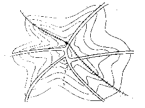
Fig 2.8 Axial Model
Source: Harvey, Jack (2000). Urban Land Economics, New York, Palgrave
The wedge or radial sector theory is a combination of the concentric-zone theory and the axial theory by allowing the spatial expansion in a more irregular mode. It focuses primarily on the locational pattern of the households and incorporates the socio–economic factors in residential locational choice. It suggests that as the city grows, diverse socio- economic groups tend to segregate. Over time, high quality housing tends to expand outwards from the centre along the fastest travel route (Harvey, 2000) whereas low income households are located on the opposite side of the CBD near the industrial land use. So instead of concentric zone there are sectors. Household sectors radiate outwards from the city centre separating the manufacturing into other sectors. Sector 1 is the central business area; sector 2 is the wholesale and light manufacturing area, sector 3 is foe low income housing groups, sector 4 is for middle income hosing groups and sector 5 is the residential site for high income groups (Figure 2.9).

Fig 2.9 Radial Sector Model
Source: Harvey, Jack (2000). Urban Land Economics, New York, Palgrave
The household land use pattern in the city depends not only on transport cost but also on similar income, taste pattern and culture. People can pay a higher rent for high income housing in sector 5 to live with residents of similar outlook and in a good environment. It is an example of the social agglomeration economies which will be analysed later. This theory gives attention to the factors influencing household locational decision in an urban area but neglects the factors influencing the location of employment opportunities.
However these theories are concerned more with the determination of residential location choice. Moreover, they emphasise more on locating the outer boundary than to find out the space economy interaction pattern within the CBD.
These assumptions of zoning where all non residential activities are concentrated only in the CBD and all housing in the surrounding ring or zone are not a consistent one when a city spatially expands over time. It is the basis of a multi centric city where non residential activities are spatially concentrated at other locations besides the CBD. The next sub section analyses the nature of spatial structure in a multi centric city.
2.4.2 Spatial Arrangement in a Multi-Centric City
The multiple-nuclei theory (Harris and Ullman, 1959) states that urban growth is manifested in multiple clusters or nuclei of complementary uses. Thus a number of nuclei exist in large cities (Figure 2.10). These nuclei are the centres of activities other than the prime centre at the CBD. Nucleus 1 is the CBD. Nucleus 2 is the site for wholesale and light manufacturing followed by low income housing in nucleus 3. Nucleus 4 and 5 are the sites for middle and high income residential groups. Nucleus 6 is the site for heavy manufacturing; nucleus 7 is the outlying business area followed by residential suburb in nucleus 8 and industrial suburb in nucleus 9.
Fig 2.10 A Multi- Nuclei Model
Source: Harvey, Jack (2000). Urban Land Economics, New York, Palgrave
There are a number of reasons for the emergence of these sub centres. These centres act as focal points for generating agglomeration economies. Secondly, the high rents in the CBD compel the firms to establish or shift their production centre in the peripheral areas. Moreover after a certain time, CBD cannot accommodate new employment due to shortage of physical space. Other areas of the city will be more attractive than the city centre for employment generating activities. The agglomeration economies of the CBD will weaken ultimately due to exhaustion of increasing returns to scale. Again, a large number of manufacturing industries do not prefer a CBD location. They require large site. The large plant size can internalise the externalities. So they avoid the exorbitant rent and heavy traffic congestion costs in the centre by choosing other peripheral locations. Moreover the firms who sell their output to outside market prefer peripheral locations for easier transportation via road networks. But the new small firms who are unable to internalise externalities still require a CBD location due to the advantages of the CBD.
The development of road transport networks over time thus encourage firms producing basic goods to locate close to highway junctions. Again the reasons for the offices to establish themselves in these sub centres are due to the decoupling of their different operations and thus using the sub centres for many back office activities, better communication and connectivity via e-mail and teleconferences. Needless to mention the spatial attributes of zones results in the formation of the sub centres and their distinctive land use patterns. Similarly from the viewpoint of the household, rising income, lower commuting costs due to better roads, a better socio cultural environment, induce people to concentrate in some particular locations.
So the growth of these nuclei or sub centres is related to the ‘range of a good and service’ and on the ‘spatial threshold’. When a city grows, it gradually diversifies various activities. The major centre at the CBD and the sub centres thus perform different functions. For specialised higher order services, citizens are ready to commute to the CBD. For other lower order services, they avail the nearest sub centre. Hence to the citizens, the CBD and the sub centres are both valuable.
A multi-centric city theory is thus a more flexible approach than the mono centricity approach. The mono centric urban land use theories assume that population densities are identical at the same distance from the city centre regardless of the direction. But in a multi centric city, the rent and density pattern are irregular ones depending on the distinctive types of land use in the multiple centres. Some sub centres which provide services like good educational, health or other amenities for the inhabitants may have high population densities and since many of them are business centres, they can reflect a residential population density crater.
However, we analysed the formation and evolution of a multi-centric city from the standpoint of mainly business activities, but the arrangement of urban sub areas is beyond the scope of just physical, economic and administrative phenomena. The spatial concentration of people in the different areas is guided also by the criterion of social agglomeration economies. Especially social stratifications besides economic stratification are closely associated with the urban multi centric spatial structure. There are also other operating forces like historical influences, topographical characteristics, cultural and political factor, size of the urban area and the role of institutions.
2.5 Conclusion
This chapter is a review of the existing ideas regarding the formation and evolution of a city from the context of space and time. They function here as the framework of our study. The chapter analyses how the urbanisation of capital is possible in a right favourable spatial set up where all the agents of an economic system, the private investors, government and the labour power interact to the formation of an urban economy. It also studies how the urbanisation process again modifies the land use pattern. The study of a city from the context of land use is a multi dimensional area. The growth pole concept or the more applicable urban hierarchy model analyses the role of localisation and urbanisation economies in the regional framework. The urban location theories explain the intra city spatial dynamics. They explain the process of transformation from a mono-centric to a multi-centric urban spatial structure. They focus on the different nature of agglomeration economies leading to the separate spatial concentration of firms and households in a city.
This chapter thus gives an idea that no single theoretical framework can analyse the dynamic urbanisation process of a city which changes over time and space. Each urban area includes different operating forces or special features. The spatial and economic interaction mechanism is not identical in all urban areas. The study thus has to be formulated accordingly considering the unique spatial characteristics besides the other factors.
Informative article . Thank you.
ReplyDeleteHello ma'am. I'm a reaserch scholar and persuing research on the same area. This article is very helpful for me to know about the origin and development of Asansol city. thank you :)
ReplyDelete