A Historical Perspective of Asansol and Its Surrounding Mining Region
3.1 Introduction
The preceding chapter explores the theories regarding the formation and evolution of a city from the context of space and time. A theoretical structure however is an abstract version of the real one. In the real world, an urban space cannot be a specific enclosed area separated from the outer world. It is an open space which is linked with the rest of the world. So, there are a number of operating forces which determine and transform the spatio economic relationship in an urban area. This study incorporates only those which are essential in our context, assuming other forces as constant.
Moreover, the economic history of any urban space can explain that there have been economies not one economy along the passage of time. The spatio-temporal flows of materials, knowledge, people and value that constitute economies can radically change from one period to another. There is no space which remains the same through time.
Hence, the spatio-economic changes of Asansol today must be read in the context of Asansol yesterday. Urban Asansol was constructed mainly in the colonial period. The study analyses the spatio-economic development of the town and the region in which the town is situated since the colonial period. The rest of the chapter is divided accordingly into six main sections.
- The physical space of Asansol
- Pre colonial era
- Flow of capital and creation of urban space in the colonial era
- The creation and expansion of Inter and intra regional linkages
- Flow of people and the reorganisation of space
- Conclusion
3.2 The Physical Space of Asansol
The name Asansol, as people say was associated with the abundance of Asan and Sal trees in the locality once upon a time. But the city Asansol rises from anonymity to a significant niche in modern India primarily because of its location in the heart of coal mines. Before studying the Asansol and its surrounding mining region from the historical standpoint, let us locate Asansol in the Damodar river valley in Map 3.1 as follows:
Map 3.1
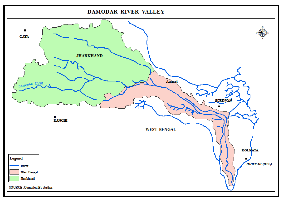
The description of physical space of the region gives an idea of this place topographically different from the other parts of Burdwan.The Chotonagpur range stretches from Rajmahal in Jharkhand to Mayurbhanj in Orissa. And it is here that the river Damodar springs from the Khamarpet hills in the Palamau district in Jharkhand and cut out its valley. Dalma, Susunia, Bagmundi, Tilbani, Jaychandi hills all belonging to the Chotonagpur range, had once upon a time as the geologists testify dizzy heights. They were snow–capped then and snow melting there-from would flow as rivulets and rivers. The river Damodar was one among them. The aforesaid hills functioned as the watershed of such rivers.
The Damodar valley comprises of 8500 square miles. There of 6960 square miles comprise its upland valley. This upland valley of the river was covered with dense forests. Asansol is situated where the upland valley meets the lowland valley. It was the space in which place is made possible.
Geologically this region differs from the plains of the rest of Burdwan district. The latter is the space rich with the agro friendly alluvial soil laden by the rivers like Bhagirathi, Ajoy and Damodar. Asansol region has undulating land littered with moulds frequently. The soil is basically red and yellow ultisols and there is reserve of valuable minerals in the underground.
The formation and evolution of an urban space is a dynamic process and the mining region of Asansol is no exception. To find out how it transformed from all wilderness to a busy urban place, the study is divided into pre-colonial, colonial and the beginning of post colonial period.
3.3 Pre-Colonial Era
The pre-colonial period can be best narrated as the pre-commercial coal mining era here. The region was not recognized at that time for its underground resources but for its forest resources. The dense forest areas of this region were inhabited originally by the Dravidian people, the son of the soil (Bandyopadhyay, 2005). The occupation of the Bauris, the most primitive class in this region were mainly hunting.
Afterwards, the relics discovered in Barakar in the neighbourhood of Asansol speak eloquently of the ancient civilization here. Archaeological remain at Andal (in the vicinity of Asansol) harks back as to the Chalcolithic period. Around 2500 years the region became the centre for Jain activity. Asansol and its neighbourhood in the Chotonagpur range was thus possibly once a busy economy. The built space of Jain temples were the centres of civilization in this region. The local oral history recalls that Parsvanath the twenty-fourth Prophet of the Jains spent a long time in this region at the nearby Pareshnath hills and Rajmahal in the vicinity was the seat of Lord Buddha during the rainy season. Those religious activities thus spread in adjoining Asansol region. But with the disappearance of Buddhism and Jainism in Bengal, Asansol and its neighbourhood became sequestered and wilderness again regained its sway over the space. The course of development is seldom linear and dysfunctions often show up. The history of a place thus cannot be a smooth temporal analysis and apt to be jarred.
However, in the later years it became part of the Vishnupur kingdom. Asansol witnessed the rule of many kingdoms at different points of time and surely their various activities modified the space of Asansol.
The importance of physical infrastructure in developing the region can be best understood with the example of the most historically famous road, the Grand Trunk Road, known as Shadak-e-Azam in the Mughal period. During the time of Sher Shah, it went past through Burdwan and Asansol to Delhi.
This built infrastructure expanded the economic activities of the space beside the G.T Road. For example, there were the inns, where the travellers stopped to have rest and feed their horses. The local oral history reveals that there was an inn where the Asansol Dak Bungalow is situated at present and there was an inn at Bogra Chatti just seven kilometres east of Asansol. The presence of these inns at regular interval might be the sign of a prosperous trade based economy of this region.
Moreover, the linkage of the space with other distant space developed the communication network, a basic requirement for development of trade centres. There were some inns initiated by Sher Shah, which functioned as both post offices as well as resting place .The word Dak means letter or postal services. The name of the inn ‘Asansol Dak Bungalow’ exemplifies the dual role of a built infrastructure at that time. Thus a space created economic activities and again the activities created new social infrastructure on the initial built space and the process goes on expanding the flow of product circulation and creating new spaces accordingly.
On either side of the G.T Road, there were deep forests comprising of Asan (Arjun or Sal) trees. But untold wealth lay about its place and its neighbourhood. The name of the river Damodar passing through this region also may be symbolic. The word Damodar has been derived from Sanskrit language. Dam means wealth and udar means belly in Sanskrit. The name fingered at the immense wealth of coal hidden in the underground for ages.
However, before the discovery of this hidden wealth, Asansol had human habitation scattered in its different parts depending on the nature of physical space. For example, the human habitation of Hirapur harks back to the 15th century. It was a seat of the Vaisnavas. Still now, there is a Madan Gopal temple reminiscent of the revered mystic Shri Chaitanya Deva.
The Asansol village had its inhabitants as well. The Ghagarburi temple dates back to 1620 AD, a place for worship of the female energy or Shakti (power) as the inscription there is an evidence to that. All these built infrastructures or their relics including the surrounding human habitations indicate flow of people and capital though they were not associated essentially with mining activities.
3.4 Flow of Capital and Creation of Urban Space in the Colonial Era
Since the colonial period, the Asansol- Raniganj region turned out to be the focus of capital flow. In a sense the urban space was created here when coal mines were found in Raniganj in Asansol region. Moreover, after the opening of the railway, the prosperity of Raniganj was assured (Paterson, 1910). Raniganj became the terminus of the Eastern Indian Railway. Coal was the source of energy in the nineteenth and the major period of the twentieth century. Though mining has the potentiality to create a link economy based on capital circulation among the different circuits of production, transportation, distribution and selling mechanism but it was only since the colonial era, that natural resource coal has been transformed into mass economic resource. There are different complex economic, technical and social conditions. Among them the basic ones are the need of effective demand that will create surplus value from production, the appropriate technology and the labour power to operate that, identification of the space to use it accurately, timely decision, governmental support and guarantee of unambiguous property rights to utilize the resources.
As we discussed in the preceding chapter, this complex mechanism of co ordination of all the activities can be logically possible only in an urban space, the space of built infrastructures. Consequently, as commercial mining started, mining areas gradually exhibited urban characteristics.
However, the process of capital circulation and creation of urban space is a long process and the spatio-economic interaction process of Asansol- Raniganj region is an evidence of that.
To begin with, coal here attracted private capital from different quarters the nature of which is to be analysed afterwards. However, extraction, processing and distribution process can be sustained only with the right kind of built space. Since it is sold outside the local markets one needs a proper infrastructure. Asansol, as mentioned before, with its rail station, loco shed and other associated services thus was a step forward to the modernization of the entire region. The economic history of this region thus became synonymous with that of coal mines, transport, industries and trade.
The growth of this region has been associated with circulation of capital among coal, industry, transport -trade and flow of people associated with these sectors. So a brief analysis in the following sub section gives an idea about the spatio temporal changes in the region leading to the formation and evolution of Asansol.
3.4.1 Nature of Capital Flow in Coal and Transformation of Space
This sub section analyses how a natural space has been gradually transformed to a built space for maximisation of economic gain in this Raniganj coal belt. Moreover it also gives us an idea about the strategy which transforms comparatively smaller segregated capital of individual entrepreneurs to agglomeration of big capital structure. This change in pattern of capital flow enhanced the scale of production which again created new space.
It was in the year 1774 that the first coal mining operation in India was started in the Raniganj coal field by the two Europeans Sumner and Heatley. Earlier too, the local inhabitants, used to lift up coal manually for their daily use. But the well organised commercial venture was launched by them. Heatley announced to have sold 2500 maunds of coal in the year 1775. But this enterprise did not make a mark in the market. The enterprise was given up. Thirty years later in the year 1804, Colonel Hardwick tried his luck in the collieries of this region. Afterwards, Rupert Jones excavated three deep mines in 1815 at Egara near Raniganj. He too did not succeed as an entrepreneur. The first Coal Company was established by M/s. Alexander & Company in 1820. A few persons however realized the future prospects of coal mining in this area. For instance, the European entrepreneur Mr Bater opened up the Chinakuri coal mine in 1823. 1n the year 1824, Jessop opened up the Damulia Colliery and Humphrey inaugurated the Nichubad colliery.
The reasons for the dismal performance of these capital owners for nearly fifty years were due to problems faced from many aspects as follows:
- Demand for coal was limited in the pre rail era.
- When the demand increased, the cost of transportation was very high due to scarcity of required built infrastructure. River transport was the only means of transportation. River Damodar, a flood prone river was navigable only for a short time period in a year making the circulation process more time consuming and less dynamic.
- Moreover, Raniganj coal had to compete quite unfairly with imported British coal.
Coal mining became a significant industry perhaps under the stewardship of Prince Dwarakanath Tagore. He purchased the coal mines at Raniganj from Alexander & Co and in 1835; first Indian Enterprise M/s.Carr &Tagore Company was formed in collaboration with one Mr William Carr. In 1843 the first joint stock Coal Company , M/s.Bengal Coal Company was formed by amalgamating the concerns of Carr, Tagore &Co and that of Gilmore, Humphrey and Co.
The flow of capital and the scale of production all depend on the demand factor and the calculation of cost-benefit factors by the entrepreneurs. The nature of demand for coal during the colonial rule in India in the nineteenth century can be classified as follows:
- Initially, gun factories under East India Company were the main consumers’ of coal.
- In the pre rail era, coal was transported along river ways as we have noted. River transport along Damodar became significant. In the year 1828, Steamer service was launched. The steamer service came into being to carry coal. As it needed coal to ply, it created new demand for coal. Therefore the linkage between coal and steamer service made the capital move from one circuit to another and produced new space for achieving surplus accumulation.
The flow of capital in the production of built infrastructure in this region can be studied from the report of the Coal Committee in 1834 (Burdwan District Census Handbook, 1951). The report investigated the prospective regions where mining would be launched. The Committee also recommended the betterment of transport facilities. It suggested forging a canal linked with river Ajoy in the Raniganj belt. It recommended a link between Damodar and Hooghly by forging another canal. The most important proposal was the setting up of railways.
The Raniganj mines made steady progress from 1847, though until 1854, there were only three mines functioning in the Raniganj coal belt.
Coal mining became regular only when the British coal magnets realized that it was economical to extract Indian coal instead of transporting British coal by steamships. The first war of Independence (1857) also underlined the exigency of transport network through out India and coal was very valuable being the only source of energy to serve railways. Since then, numerous small entrepreneurs also entered this field.
Opening of rail transport in India was a significant event for the whole of Raniganj coal belt and especially for Asansol. The contribution of rail in the expansion of coal economy and in the growth of Asansol in the colonial period has been immense and the next section analyses it in details.
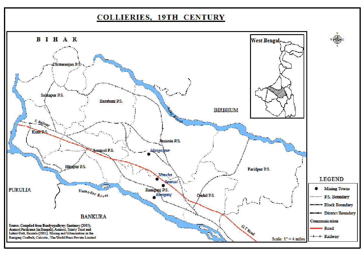
In the meantime, the demand for coal attracted more capital in this space and quite a few coal companies were set up in the neighbourhood of Raniganj. The Bengal Coal Company was their pathfinder. A few of them are listed as follows in table 3.1 and in the map 3.2.
Table 3.1
Name of the Owners and Location of Colliery set up in the Middle of the 19th Century
Owner
|
Location of Colliery
|
Bengal coal
|
Raniganj
|
Babu Gobinda Prasad Pandit
|
Searsol
|
Kailasnath Roy
|
Damulia
|
Sukhamay Nandi
|
Nimcha
|
Tarachand Pal
|
Mangalpur
|
Rani Swarnamoyee
|
Bansra
|
Source: Bandyopadhyay, Santimoy (2005). Asansol Parikrama (in Bengali), Asansol, Trinity Trust
This table is an evidence of the interest of the landlords in the colliery business. These investors played an important part in shaping the economy of this belt. So from the beginning of the early nineteenth century, Asansol attracted both Europeans and indigenous investors. Many of these investors operated through managing agencies.
Map 3.2
In the industrial history of this coal belt, the role of agency houses in the colonial period could not be ignored (Rothermund, 2000). The role of the managing agency Carr, Tagore and Co was quite remarkable here. These agencies offered a package deal for everything that was in short supply in India like industrial capital and technical know- how. Initially a managing agent was just an executive who helped an entrepreneur unfamiliar in local condition to establish and run a coal mine. They were compensated by getting 10% of total turnover as commission and were managing a number of firms simultaneously Afterwards, there was a reversal of the roles of managing agencies and entrepreneur. Success, experience and creditworthiness enabled the agencies to float new companies themselves. An important subsidiary role was played by the agency houses which had grown up in Calcutta in this period.
The coal mines during that period created enclave economy with extraction of coal for exports. The enclaves were interconnected only by means of the managing agencies that controlled all these activities. Otherwise they remained isolated from each other and from their respective hinterland. Even the food of the miners was transported by railway from distant plants. So the region as a whole did not gain at that time from agglomeration economies.
As the primary regional economic development here was mainly based on coal, a brief account of the growth of coal industry can give a clear picture of this region. The investors in coal sector enjoyed their first taste of profit during the period of First World War. The coal mining in India i.e. the Bengal coal production hugely benefitted from that war. Until the beginning of the First World War, coal imported from England was cheaper in Bombay than the Bengal Coal in Calcutta, which was mostly consumed by East Indian Railways and exported to the east. Import of coal reduced from 1914-1916. But during the World War, Indian coal captured all the Indian market. Annual average production increased from 11 million tons in 1906-10 to 20 million tons by the end of the war. The price of coal, in spite of the rise in supply rose from 3.80 rupees per ton at the beginning of the war to 4.60 rupees at the end. The increased production at higher prices brought windfall profits for the coalmine owners.
But, the surplus was transferred to other areas. The mining region remained simply the lucrative space for extraction of this precious fuel energy. The mines were operated in a very primitive way with only minimal investment, few permanent staff and meagre wage to miners. However, production of coal at a low price did not benefit the industries that needed this fuel as the railways charged high freight rates for transportation of coal to the industrial centres.
So it is quite understandable that the managing agencies, the capital providers of that time were not interested in investing huge resources necessary for sustainable development of the mining region. Instead, they were interested in earning quick profit. There are no available data which could prove any concern regarding the protection of land after extraction of coal.
However, as mentioned earlier, the investments created a few urban places in the region. For instance, the colliery area of Mangalpur, some two miles from Raniganj was more important than Raniganj itself till 1855. There was a sizable locality associated with the capital circulation process. The police station, criminal court, lock-up and post offices were situated only there.
Raniganj at that time was mostly an uninhabited virgin space and in the area named Khantsuli just a few huts occupied by the poor families of goalas (cowherds) and Muhammadans existed while the eastern edge was basically agricultural land. During the Sepoy Mutiny or the first war of Independence, Raniganj became the terminus of the East Indian Railway and a temporary cantonment for the troops was established at Khantsuli. It was known as Gorabazar or the ‘white soldiers’ market’ at that time. After the opening of the railway, the prosperity of Raniganj was assured (Paterson 1910).
Consequently, in the year 1855, the police station and post offices were shifted to Raniganj.The event was an important one at that time. Sambad Prabhakar, a daily newspaper at that time published a report on this event on 21st March 1855.
So the flow of capital in built space like transport network prompted in the creation of new administrative spaces in Raniganj and the transfer of the administrative control centre from Mangalpur. Thus the development of Mangalpur as a central town in the region became stunted. On the other hand Raniganj, situated on the north bank of the Damodar River was becoming the queen of the region because of its wealth of coal and rail and new administrative status. The population in 1901 was 15,841 (Paterson 1910). The profit spinning primary circuit coal led to spill over and creation of the secondary circuits of paper mills, extensive potteries and oil mills.
Uninterrupted capital circulation cannot be possible without a smooth flow of labour power. Construction, maintenance and operation of any type of built space, be it mining, transport or industry require labour power. In mining sector, migrant labourers were given free cultivable lands by the employers (Das Gupta, 1985) .The potteries gave employment to nine hundred persons and the value of output in 1909 was 3.18 lakhs. Paper mills employed 1,100 workers and in the same year made 5,394 tons of paper, valued at Rs 16.36 lakhs. Thus an impressive turnover of capital was the reason for the growing prosperity of Raniganj at that period.
This is an ongoing process by which the new space is produced and some earlier created space may decay due to lack of capital inflow. The first group of people are apt to settle at the most convenient site for fulfilling their purposes. Gradually, the technological progress and their application add fresh utilities to the land unused earlier. The focus of trade and commerce thus shifted accordingly.
Raniganj thus earned the top ranking position in this mining belt during that period. The name Raniganj was mentioned in a government document in 1774. The name was derived from the proprietary rights of the collieries having been vested in the late Rani of Burdwan (Paterson, 1910). We mentioned earlier it was in that year indeed that the first attempt at mining was launched there. Raniganj was sparsely populated at that time.
By 1876, when the coal mining became a significant capital pulling sector, it became agog with business activity centred on coal. The non agricultural nature of that space became apparent and Raniganj earned the status of a municipality.
But the centre of power was soon shifted from Raniganj to adjacent Asansol within a short span of thirty years. The Asansol sub division took shape towards the end of the 19th century. The nature of urban hierarchy will be discussed later.
3.5 The Creation and Expansion of Inter and Intra Regional Linkages
Circulation of capital in a space requires the material construction of a built environment and specific spaces in which the economic activities can be performed. For the successful transformation of coal from its status of natural mineral to natural resource, capital investment for development of infrastructure is a necessity.
Moreover, in the colonial era, i.e. in the eighteenth, nineteenth and even in the early twentieth centuries, India was exclusively the source of raw materials for British industry and was a market for British goods. To extract and exploit them, the main concentration of the British was on transportation and communications. Thus Railway was one of the initial essential built infrastructures in pre-independent India.
Railways played a big role in inter and intra regional connectivity and in this process shaped the urban Asansol gradually. The economic development in the Asansol region accelerated along with the beginning of the operation of the East Indian Railway. The most important trade carried on between Calcutta and Burdwan was coal. From 1830’s the demand for coal as the source of fuel increased due to newly introduced steam vessels on the rivers of India. But the navigability of river Damodar was not same for the whole year, disrupting the production-distribution linkage mechanism.
The idea of the East Indian Railway (E.I.R. henceforth) originated purposefully for the linkage of city of Calcutta with the Burdwan coalfields. The commercial importance of this line was enormous. The journey saved time with added advantages like lesser cost, more comfort and security thus making the line remunerative and accelerating the development of existing trade.
In February 1855, the experimental line of the E.I.R. from Howrah to Raniganj (194 km) was opened. The possibility of obtaining fuel at a cheaper rate acted as direct impetus for the growth of other new industries in Calcutta and its neighbourhoods, e.g. the growth of jute industries. In the middle of the year 1855, the locomotive department of the E.I.R. succeeded in using the Burdwan coal without coking it for their locomotive purposes. (Mukherjee, 1994).The first war of Independence, 1857, forced on construction of more rail lines for administrative exigencies .Consequently Indian railways became the largest consumer of Burdwan coal.
The increasing supplies of Burdwan coal from 1855, thanks to railway transportation led to reduced price in comparison to that of the imported coal. Two other railways, the Eastern Bengal Railway and the Bengal Nagpur Railway besides the E.I.R. were its major consumers.
Due to rise in demand for coal, the expansion of different branches of rail to connect different collieries were rapid and successive in the sixties of the nineteenth century. Examples of some intra regional linkages were Andal- Ikra- Sonachura line (1863), Gourangdi loop line (1864), Andal-Ikra-Barabani(1864) and Sitarampur- Barakar(1865) ( Bandyopadhyay, 2005). They were the examples of old guarantee system of 1849-1869. During that time period, railways were constructed by private British companies relying on capital raised in England with a five per cent guarantee backed by the colonial government of India. These projects suggested that the government anticipated the potential demand for coal and considered this region as their economic resource base. Moreover they also considered the probable passenger flow associated with coal economy. More rail lines were constructed for serving the coalfield areas of the Asansol sub division like Barabani-Tapasi, Kalipahari-Damodar and Barachak-Hirapur sections. The line between Asansol and Damodar stations measuring 7.43 kilometres and forming a part of the Asansol-Adra section of the South-Eastern Railway was opened as early as on 1889. Thus it is an example of how capital circulates from one sector to another and creates organised space.
The year 1863 should be mentioned as significant in the space–economy study of Asansol city. In that year, railway was extended from Raniganj to Asansol old station area. Railway quarters shot up to accommodate the railway employees creating an urban atmosphere with the architecture of red brick buildings in a planned style.
The reorientation of space continued. Next year the rail line extended up to the junction station. The E.I.R. was extended to Barakar in 1865. From Asansol a branch of the Bengal-Nagpur Railway connects the main line at Sini (Paterson, 1910). The line was then extended towards Delhi.
3.5.1 The Evolution of Urban hierarchical Structure in the Region
The beginnings of the Asansol Township were forged however, under different circumstances. It has been mentioned that one Tinkari Roy, an Aguri or Ugra-Kshatriya cleared the forest here. The property rights mainly belonged to these Ugra-Kshatriyas who owned wide expanses of land at Asansol. They owned the land where Santa village stand today. Those Ugra-Kshatriyas used to reside at places known as Asansol village and Budha locality. Miles away from these localities their place of worship Ghagarburi temple was situated. Surely, as mentioned earlier, there was a locality in its neighbourhood.
The earlier chapter discussed the nature of urban hierarchy in a region. A region needs urban centres of different size for co coordinating different activities. The establishment of rail station is an evidence of that. The cargo of coal needed a larger space for railways. Land was not available to them as Bengal Coal Company did not cooperate with the railways in this context. In 1862-63, a grant of Rs 94,694 was given for construction of a larger railway station and loco shed. Asansol loco shed officers colony was established in 1885.
There is another local story of this non availability issue. It is that the land owner class of Raniganj at that time, the Rajas of Searsol were not interested in giving land for building of railways at that time. May be the opportunity cost of transferring the land to railway authorities was higher than the surplus value they earned from excavating coal from that space at that time. Rail station was built up at Asansol as the local landlord and the owner of capital; the Rajas of Panchakot gave land for, building the railway station, now one of the busiest stations of India.
As Raniganj was the busiest town at that time and it was also the main hub of the collieries, the price of land must have been higher than the neighbourhood areas in the region in those days. Moreover, there might be scarcity of required abundant surface land for rail network or the authorities feared that it might create an unsustainable situation to built huge infrastructure for rail due to the presence of coal in the underground.
Be that as it may, it proves that a region requires more than one urban centre to execute its various functions. The first railway colony in Asansol town was raised in the vicinity of the old station and it still lingers. Afterwards, the new bigger station was constructed enlarging the colony area flanked by Jehangir Nagar on one side and Aguri locality, one of the oldest residential areas of Asansol on the other. It had become one of the largest railway settlements in India. There was a large European community in the rail services and the markets were growing fast.
The railway station and the associated tertiary services provided here the necessary incentive to urbanization. Asansol practically became the nerve centre of the region after the establishment of Asansol division, one of the oldest divisions of the Indian rail.
As mentioned earlier, Asansol was also gifted with the Grand Trunk Road. In the pre rail period, it was an important trade route. But, the arrival of railway someway lessened the importance of this road transportation in the nineteenth and in the first half of the twentieth century as mass road transit system was comparatively less modernised than that of rail. So railway became the dominant mode of transportation both for cargo and people. However, from the middle of the twentieth century, since the development of automobiles, road transport also became brisk.
The production of built infrastructure like rail line and junction rail station at Asansol helped in the flow of capital into the primary, secondary and tertiary activities. The establishment of different administrative headquarters or their gradual relocation from Raniganj to Asansol reorganised the intra town spatial structure and modified the economic activities of the place.
Raniganj being the first coal town was the dwelling place of the blue collar workers, the miners who mainly belonged to the lower socio- economic status. Exclusive separate space was constructed for white collar officers in Asansol adjacent to Raniganj. The want of privacy was one of the causes for the setting up of this built space in Asansol. Gentrification is a major factor for creation of separate urban space almost everywhere and that explains why Asansol was focussed.
Asansol was constituted a Municipality in 1885. Raniganj was initially the head quarters of the sub division, but in 1906, the sub divisional Magistrate’s Court was removed to Asansol. It was the head quarter of the Asansol subdivision and became the main urban centre of the region with the sub divisional offices, civil courts, post offices, police stations and other staff of colonial administration. The administrative circles of Asansol then covered the thanas of Salanpur, Kulti, Hirapur, Asansol, Barabani and Jamuria. Asansol sub division was about 60 miles in length then. The importance of the town increased rapidly. The East Indian Railway Volunteers had their head quarters at Asansol. There were large railway works at Asansol and the Locomotive shop employed roughly 113 in 1910 (Paterson, 1910). The head office of the Bengal Coal Company was established in Sanctoria in 1910. Besides, the missionaries had already set up schools, church, orphanage, leper asylum etc. The church had property rights over a large tract of land and a Christian community flourished under their patronage.
Moreover, as coal of superior grades were available at the western parts of the Raniganj coal belt (Paterson, 1910), Asansol gradually transformed itself into an urban space. A sign of the urban character of the town was that most of the houses in the town were brick built and roads were well kept.
But it was the setting up of Asansol loco- shed officers’ colony in 1885 that gave a new dimension to the population of the town. While the Budha village was situated in the south of the G.T Road, the Asansol Railway colony shot up in the north of the G.T Road on either side of the old station at the outset. The old railway station was in the north of the G.T Road. Later on the new station shifted westward in the north of the G.T Road, almost at the opposite of the Budha village across the G.T Road. These railway colonies housed rail employees from different regions. The drivers were mainly Anglo Indians. There were workers from all over India. Besides there were white collar job holders, the majority of them were Europeans.
As Paterson (1910) observed, Asansol was the most densely populated Thana of the district with 839 persons per square mile. The flow of people in the town created new demand for built space like intra town road network. Consequently, the city witnessed some new road space in the early twentieth century like N.S. Road parallel to the G.T Road, the Young Road (now known as Sashibhusan Gorai Road), Ramgulam Singh Road and Nurrudin Mistri Road.
Coal and rail attracted a set of industries in this region with forward and backward linkages among them. Iron and steel industry along with the planned township of IISCO at Burnpur in Hirapur, adjacent to Asansol town took off in the early twentieth century. The steel towns generally begin at a place where there is little or no human habitation as they require huge space. The steel plants created organised space, the pattern of which will be discussed in the next sub section.
The engineers or managers of both Rail and Steel Plant consisted of Europeans and their assistants were educated natives of our country. It was they who brought about a new culture which opposed the traditional one. The railroad tracks practically acted as a divider in the colonial period between the, colonial, modern, business oriented area and the traditional areas. The British administrators thus created new spaces rather than accommodating themselves to existing structures. The first population of the new township of Asansol comprised of coal mine workers, steel plant workers of different tongues and the Englishmen supervisors and the railwaymen who consisted of both the natives and the Europeans. It was culturally very much different from Burdwan town in particular and south Burdwan district in general. The elite in the southern part of the Burdwan district in the nineteenth century chiefly comprised of the new landed aristocracy that emerged during the Permanent Settlement.
Thus Asansol became a melting pot of people from different socio- economic and cultural background and the way of life was a mark of urbanity which was missing in the other parts of Burdwan. Burdwan town was more homogenous and dominated by princely rulers. The development strategy was different for them .The nature of both physical and social space differed in the two towns of the same district Burdwan and Asansol. While the landed gentry along with the Maharaja of Burdwan focussed on the development of education in Burdwan town, the increasing importance of Asansol as an industrial centre made it a home for people with active role in different circuits of economic production. In addition to the labourers in the different production sectors and the high rank management groups, the town attracted the diverse professional class of lawyers, traders, politicians, doctors and teachers who formed the so-called elite and constructed the space as evident of growing urbanization.
3.5.2 The Economies of the Space
This sub section studies the agglomeration economies which this industrial region has enjoyed for a long time span.
The history of any large scale production in Asansol in the pre coal era is virtually unknown though weaving of woollen blankets was an old time industry here (West Bengal District Gazetteers, Barddhaman, 1994). However, the mineral endowments and other advantages transformed it into a space for circulation of industrial capital especially in the heavy industries like iron and steel and others. The concentration of the different spatial endowments such as iron ore, coal, limestone, dolomite, manganese and nickel in the nearby plateau area made possible the construction of a number of iron and steel plants like Kulti and Burnpur, Jamshedpur and in the post independence period Rourkella, Durgapur and Bokaro in the Eastern India.
In the context of why and how the iron and steel industries flourish and their contribution in the production of urban space in the Asansol region, let us focus our attention to the two industrial urban spaces Kulti and Burnpur and the size of activities in the industries there. A map of the steel area (map 3.3) shows their location.
Map 3.3
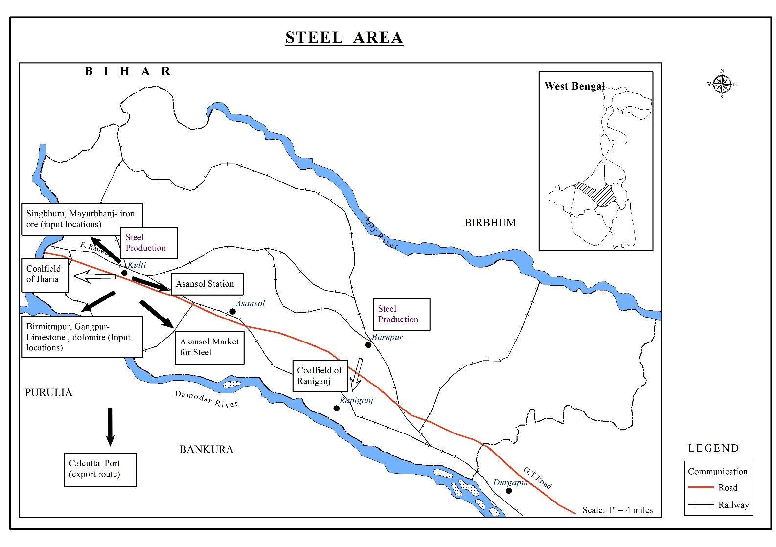
Source: Compiled by the author
India’s first blast furnace was built way back in 1870 at Bengal Iron Works in Kulti in the Asansol division, when even in the industrially developed countries there were few blast furnaces. That was the oldest unit for manufacturing pig- iron and iron casting in India. In 1874, the Bengal Iron Company started its production in nearby Barakar .It was afterwards sold to the Bengal Iron and Steel Company. It took over Kulti Works in 1890. Steel was made for the first time in India in 1904 here in open hearth furnaces. However, it lost to cheap steel dumped from England. Steel making discontinued and Kulti became famous as iron making plant. The total quantity of iron produced during 1908 was48, 906 tons valued at Rs 27,13,625. The average number of operatives employed daily was, 2,934, and most of them were housed in coolie lines near the factory (Paterson, 1910) . Besides using in rail and other indigenous industries, iron was also exported at that time. During the Second World War period and the years that followed foreign export was completely suspended as a result of increased demand in the country (West Bengal District Gazetteers, Barddhaman, 1994).The industries in India expanded rapidly during this period. The steel plants at Kulti and Burnpur functioned as complimentary to each other. While Kulti produced mainly pig iron, Burnpur produced both pig iron and steel.
The economies of the space are summarised as follows:
- The coalfield of Raniganj and Barakar are at hand and that of Jharia is 136 Kms away.
- Iron ore is obtainable from Singbhum area of Jharkhand and Mayurbhanj area of Orissa.
- The river Damodar is nearby.
- Limestone, dolomite etc are available at Birmitrapur and Gangpur of Orissa. Manganese and limestone are transported from Singbhum and Mayurbhanj.
- Heterogeneous labour is available from West Bengal, Jharkhand and Bihar (different parts of Bengal Presidency at that time) and other parts of the country.
- Well developed rail and road connection.
- Calcutta port is 217 km away.
- Asansol itself becomes a market for steel since for different secondary industries in the region.
- This was one of the regions where thermal power was first generated and used for industrialisation in India.
So the iron industry here is an example of the organic relation between space and economy. Economic exigencies and the threshold size of activities create space. When space is developed, economic changes are there. The coal mines reproduced the Raniganj area. It drew rail and afterwards iron and steel foundries in the vicinity. All of them once again took active part to develop the space called Asansol by drawing the in migrants who sought to join in the capital circulation process generated by the mines, the plants and the other sectors. They again reproduce the space according to the changing requirements and the interaction goes on.
The contributions of the built infrastructure like electricity and water supply were immense in the creation of this industrial region. Dishergarh Power Supply Co Ltd installed a steam- power station during 1920. Dishergarh Electric Supply Co. started distribution of power at high voltage to the collieries in the area as well as other distributing licensees of which Asansol Electric Supply Co. was the first (West Bengal District Gazetteers Barddhaman 1994). Electricity and piped water were introduced in the town in the thirties of the last century. The pump operated with the electricity was derived from the IISCO.The same system continued for a long time even after 1947. The Budha reservoir was built in the British period with a capacity to serve 500 people.
The planned development of the space Burnpur was a contrast to that of the spontaneous urbanization of Asansol. Generally, there are a number of phases in the growth of the built space of steel towns. At the outset, the necessary infrastructures like roads, bridges, railway tracks and power plants have to be forged. Drainage system and water works must be constructed. The next stage witnesses the building up of the factories and the adjacent township where the employees of factory should be housed. These two stages need a large number of construction workers. In the third stage, the core sector generates a number of subsidiary industries. Finally, the service sector began to flourish there. It includes medical service, education, credit and finance sectors etc.
The Indian Iron and Steel Company Limited (IISCO) started their production of iron in 1918 at Hirapur. It was a small hamlet amidst the Sal forests. It transformed into a distinct township away from Asansol. True, that there was a nearby age old human habitation at Hirapur. But the employees of the newly formed iron and steel company forged a new space in Santra. Nearby villages were Narsinghbad, Napuria, Dharampur, Rangapara, Kalajhora, Nabaghunti, Nakrasota and Chotodighari. The name of the industrial township became Burnpur after the managing agent Martin Burn and Co. The railway track of Bengal Nagpur Railway was there with a small station named Narsinghbad. It was later named Burnpur. The labourers and the sweepers at Burnpur settled at Narsinghbad. That was how fresh habitations started with the birth of iron foundry at Burnpur. The urbanisation of Burnpur was due to the initiative of a few entrepreneurs, but it was not so for the case of Asansol. For instance, G.H Fairhurst the first General Manager of IISCO was instrumental for founding and developing the township. The development of Burnpur owes heavily to Sir Biren Mukherjee of Martin and Co.IISCO took over Bengal Iron’s Kulti Works in 1936.
IISCO directly activated the growth of the whole region from 1925 to1934. The Indian Standard Wagon Factory (later renamed Burn Standard), set up in 1918 also shared the land with IISCO. Kulti and Hirapur were developing, labour colonies were planned and markets were expanding. The main market was founded in 1937. Steel Corporation of Bengal (SCOB) set up the steel plant at Burnpur adjacent to the iron making facilities of IISCO in 1939.The village of Napuria was absorbed by the plant for steel making. Burnpur, however, was destined to be joined with Asansol in times to come to raise Asansol Corporation.
Gradually this region turned out to be the centre of localisation and urbanisation economies. Aluminium plant was established at Jaykaynagar, midway between Asansol and Raniganj in 1938. It was famous for the production of a considerable amount of aluminium in the subsequent years. Its input Bauxite was at Lohardanga in Ranchi district and at Khamar in Palamau district in Bihar. The strategic location of this place and its good connectivity with the outer region might act as the decisive factor for the establishment of this plant here. Again, for construction of factories and other built structures, several refractories and engineering workshops flourished in the neighbourhood consequently.
Thus the advantage of spatial resource and subsequently capital circulation process here generated agglomeration economies. The cluster of different ancillary industries complemented each other and expanded the arena of investment flow. For instance, liquid Oxygen Explosives are essential for blasting in open cast coal and metal mines, under watery blasting etc in this belt. Indian Oxygen Limited started an oxygen compressing station at Burnpur in 1941. Within a decade and a half, the demand for gases increased greatly creating demand for opening of a larger factory at Asansol. It is an example of backward industrial linkage. Asansol region became the Ruhr of India.
Additionally, in the early years of the last century, Asansol was a very large centre for producing tiles, clay products, pottery and refractory. The business of fire clay expanded in Churulia- Chichur Beel, Ramnagar-Salanpur and Gaurandi-Samdi region from 1910-15. Iron utensils were made throughout the district. In 1890, Messrs Burn and Company’s pottery at nearby Raniganj was famous for industrial art. At that time, the company employed some 600 men for the manufacture of bricks, tiles, drain pipes as well as terracotta vases etc (West Bengal District Gazetteer, 1994).
Biri were manufactured at Asansol (Paterson, 1910).The biri production expanded in places like Churulia and Itapara. Chanda, Ranisayar, Sodepur, Chinakuri, Neamatpur and neighbouring areas were centres of iron wares. There were flour mills in Asansol and Raniganj.Oil and rice mills were scattered through out the district. Ice and aerated water were manufactured for local consumption at Asansol, Raniganj, and Sitarampur (West Bengal District Gazetteers, Barddhaman, 1994). Since 1910, traders from north eastern states bring woollen garments here. Still now the seasonal Potala Market near Asansol is famous for the winter wears Cotton wear production started at Madhudanga and Kelejora.
As to trade, the chief articles of export in that period were coal and iron. An important import item was salt. The chief centres of trade were the towns of Asansol, Raniganj and Burdwan. The well provided communication network helped in expansion of trade.
Expansion of mining, industrial, administrative, trade and other activities here led to a rapid growth of population. It attracted in migrants from far and near. The next section studies the flow of people in this region.
3.6 Flow of People and the Reorganisation of Space
Asansol was a mouja under the jamindary jurisdiction of the Rajas of Panchakot (Kashipore estate in Purulia).The landlord of Kashipore distributed ten bighas of land for khajna (rents). Thus the original inhabitants of Asansol were peasants. We have mentioned already that these first settlers here were Ugra Kshatriyas or Aguris. The Aguri were widely distributed in the Burdwan District. They largely dominated the socio- economic and cultural milieu of this district. With the discovery of coal, no wonder, fresh migrations to Raniganj and its neighbourhood started.
3.6.1 Course of Urbanisation
Before going to the detailed interactions between people and space, let us have a look at the statistics to understand the volume of pull here.
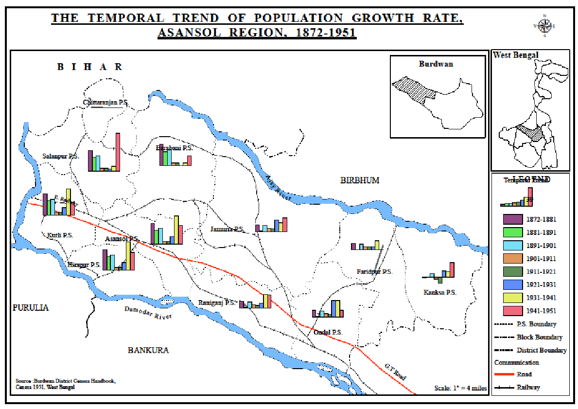
The following table 3.2 and the map 3.4 depict the percentage variations in population from decade to decade in the Burdwan district, Asansol subdivision and in the administrative divisions within the sub division during 1872-1951.
Table 3.2
The Temporal Trend Of Population Growth Rate, 1872-1951
1872-1881
|
1881-1891
|
1891-1901
|
1901-1911
|
1911-1921
|
1921-1931
|
1931-1941
|
1941-1951
| |
Burdwan District
|
-6.2
|
0.0
|
9.8
|
0.4
|
-6.5
|
9.8
|
20.0
|
15.9
|
Asansol Sub Division
|
19.4
|
9.1
|
19.6
|
4.7
|
4.0
|
14.6
|
30.8
|
27.0
|
Salanpur
|
43.1
|
28.8
|
31.8
|
5.6
|
5.7
|
4.9
|
10.8
|
78.0
|
Kulti
|
43.1
|
28.8
|
31.8
|
5.6
|
5.7
|
15.4
|
53.7
|
26.6
|
Hirapur
|
43.1
|
28.8
|
31.8
|
5.6
|
5.7
|
15.4
|
57.8
|
37.6
|
Asansol
|
43.1
|
28.8
|
31.8
|
5.6
|
5.7
|
15.4
|
57.8
|
37.6
|
Barabani
|
43.1
|
28.8
|
31.8
|
5.6
|
5.7
|
0.2
|
5.8
|
19.1
|
Jamuria
|
13.2
|
0.9
|
12.1
|
6.0
|
5.6
|
23.3
|
17.8
|
27.2
|
Raniganj
|
13.2
|
0.9
|
12.1
|
5.9
|
5.6
|
9.9
|
28.1
|
26.0
|
Ondal
|
13.2
|
0.9
|
12.1
|
5.9
|
5.6
|
34.0
|
34.2
|
14.0
|
Faridpur
|
13.2
|
0.9
|
12.1
|
6.0
|
5.6
|
6.0
|
18.6
|
0.8
|
Kanksa
|
-1.3
|
-0.3
|
6.3
|
-4.6
|
-12.8
|
12.4
|
11.2
|
29.6
|
Source: Burdwan District Census Handbook, Census 1951, West Bengal
The above table shows that the growth in Asansol sub division was marked as phenomenal. Since 1872 (the First Census of India), there has been uninterrupted increase from decade to decade. According to the Census of Burdwan 1891, the increase in population in Asansol Thana was exceptional, i.e., 28.9% (Burdwan District Census Handbook, 1951).The development of the infrastructure, the railway works at Asansol consequent on the opening of the Bengal-Nagpur Railway and the rising activities of the coal and iron fields attracted a large in migrant population from Manbhum, Bankura and Bihar. Between 1872 and 1921, it was 69.7% of its 1872 population. Maximum growth of population (171.3%) was recorded in Salanpur, Kulti, Hirapur, Asansol and Barabani, and a much lower appreciable growth of 43.3% was registered in Jamuria, Raniganj, Andal, Faridpur police station. The population growth was mainly related to the coal and railways.
Map 3.4
After 1921 it was more eye-catching due to the opening of industries here as referred to earlier. There was increasingly greater proportion of adult immigrants in the population of Asansol due to job requirements. Moreover, around 1921-51, every part of the district except the industrial areas of Asansol subdivision, suffered from a decrease in population mainly due to floods and epidemics. After the riot of 1946, a few colonies of Bihari Muslims were settled in Asansol sub division; but almost all of them left before partition.
Ethnically there was a wide difference between the Asansol subdivision and the rest of the district. Paterson (1910) reported that in Asansol the lowest stratum of the population to be found was the Bauris. But even in the earlier decades of the nineteenth century this tract was mainly an unpeopled wilderness. Since the discovery of coal, it turned out to be a habitat. Original inhabitants were aboriginal tribals namely Bauri, Bagdi, Santal, Kora and Mahali. Their main occupation was agriculture. In 1881 Asansol was a rural tract. In 1891, its population was 11,000, and in 1901 at 14,906. The municipality area by 1910 was 3.73 square miles and its population was approximately 18,000.The largest land owner at that time was the Bengal Coal Company. The expansion of coal and iron, the rapid developments of the factories and the great railway centre had created a new interdependence between capital and labour. The Bengal District Gazetteer 1910 reports Asansol was at that time, the most densely populated Thana in the district with a population density of 839 persons to the square mile. The growing demand for labourers in the mines and factories here led to a large number of periodic and permanent in migration from the contiguous districts of Bankura, Manbhum and Santal Parganas.The labourers for coal mines, iron works, paper mills and potteries were collected in large numbers from Patna, Gaya, Shahabad, and Munghyr in Bihar and from the Chota Nagpur plateau. The large immigrant population were mainly housed in small groups of huts clustering round the various mines and factories.
The increasing trade attracted a large number of Marwari traders and merchants and entrepreneurs from different regions. The Armenians also set up business in Asansol in connection with collieries. They are no longer there in Asansol but such localities as Apkar Garden and Dhadka still bear their name.Gujratis, such as Mr Chanchani owned quite a few collieries. With them a considerable number of Gujratis came to the colliery belt as their employees and settled in Asansol. The town attracted people from diverse religious belief. The Muslims were old time resident here. The local oral history states that they came during the reign of Mughal Emperor Jehangir. At present, the two age old slums within Asansol Corporation area the Kasai Mahalla and Jhingri Mahalla (or Jehangir Mahalla) still reminds that.
Till the 1920s the coal belt labourers consisted of villagers at trekking distance and the aborigines from Santal Parganas.They mostly migrated in family groups. While the adult male cut the coal at the pit face, women and children loaded it in baskets and tubs and carried it to the shafts. In early 1920s, women constituted around a third of the total mine workers (Das Gupta, 1985).The migration was not the typical rural- urban one as most of the collieries were then situated away from urban sites and labourers seldom visited the market towns in those days. They spent their surplus earnings in feasting or at grog shop (Burdwan District Census Handbook, Census 1951, West Bengal). They were very much rooted in their native villages and agriculture. Though employed in the mines at about a double pay than an ordinary peasant, they rarely remained long in regular employment.
In the second decade of the twentieth century, particularly during the World War and after war years the industries in India expanded rapidly. The increased demand for indigenous coal occasioned the expansion of the labour force. As mentioned earlier land were granted to them. The process continued with more land grants. To keep them tied to the coal mines and to counteract the tendency of the labouring class who were chiefly target labourers; the Bengal Coal Company gave each man a bigha of land and five cottahs of garden land. But the Coalfield committee of 1920 observed that even land allotment to the miners did not give them any sense of belongingness to the collieries. Their social space or the freedom they used to enjoy might be different from the harsh life of coal miners.
However, the above mentioned efforts were not wholly in vain. In Raniganj area fifty per cent of the labourers were settled in the coal belt. But recession followed the boom of the after-war periods. The coal industry passed through a phase of stagnation. In those days land produced only one crop a year. Seasonal unemployment was prevalent. With the opening of the coal mines, people went to the mines only for the time when there was no agricultural work.
Since 1920s, upper class people from Bihar, Uttar Pradesh and the then Central Province also slowly flocked into the coal mine belt. In the meantime, the technology of coal extraction was fast changing. Handling of explosives, emergent coal cutting machines needed skill and technical know how. Besides, coal mines set up regular working hours, creating a new ethos in the coal belt. The ethos practically developed due to the surplus creating objective of the managing class. The adivasis could not cope with this new ethos. But the upper class people migrating from UP and Bihar were found to fit in this emergent system. So henceforth, with the change in the composition of the labouring class more people, some forty per cent settled in the collieries.
Curiously enough, the non-local, non-tribal migrants to the collieries, who figured a significant proportion in the labour force, consisted of the males only. Their family lingered in their native places. Since 1930, women could no longer work underground. That also decimated the number of women among the labourers. It also restricted the women’s space in the mining region.
Despite that, an increasing proportion of the labour force was tending to settle down permanently in this region reproducing space though their ties with traditional homeland and customs continued. The curiosity may arise as to why the labouring class continued to remain as half miners and half peasant still in the 1940s.The contrast with the British mining labour force is a classical one. There they lost all contact with agriculture. We feel that the difference between Indian and British labour force is due to different historical context. Lives of the peasants in medieval Europe were simply unbearable. They had to work as serfs under the barons and had little or no freedom. On the other hand in the then Bengal, the traditional system of ownership of land gave a lot of freedom to the farms unlike the industries. Still they served the industries only for liquid money.
At the same time, the narrative of migration to the coal belt shows how slowly, the migrated labourers started to settle in the coal belt. Right now, the very city of Asansol or the Corporation area has in it a number of collieries. Earlier they were not known as Asansol. But around these collieries, such as the Girmint colliery, the habitations of the labourers gradually growing into small villages cropped up. As we shall see in the later chapters, they all joined to build up the city of Asansol in times to come.
Again, in-migration created avenues for new investment. As a large number of Europeans and Anglo Indians were already residents of Asansol for their services in railways, as managers in the collieries in Raniganj and surroundings, they needed different tertiary services, especially education.
The demand for educational services increased. Missionaries played a large role in this respect. The European missionaries set up the first schools at Asansol whereas in nearby Raniganj it was developed by natives. The Catholic Mission set up the Loreto Convent in 1877. Saint Vincent school was also launched in that year. Saint Patrick came up in 1891.By 1904; Ushagram Boys School was set up by the missionaries. There were three schools for Europeans here (Paterson, 1910). They were the Railway school for boys and girls, St. Patrick’s boarding school for boys and the Loreto convent for girls.
There were 8 colliery pathsalas (space for primary education in vernacular language) in 1908-09 in the Asansol division, which, received grants of Rs800 made by Government for the education of the miners’ children (Paterson, 1910).
Asansol as an urban space was different even from its neighbour town Raniganj and surroundings as it was dominated by the Europeans. In other words while Raniganj was left to the native to be constructed as an urban space, the Europeans chose Asansol for economic activities.
The last section summarises our inferences.
3.7 Conclusion
This study of the historical perspective of Asansol and its surrounding mining region analyses the numerous operating forces in the formation and evolution of an urban economy. A town has a specific geographical area but its growth or decay depends on a large extent to external factors, many of which are even beyond the control of the nation.
In Asansol region, the space transforms from wilderness to a busy mining based industrial urban agglomeration due to flow of capital and subsequent construction of built infrastructure, flow of people, setting up of linkage industries, creation and expansion of inter and intra regional linkage.
Colonialism played a major role in this regard. Our study discusses it in the above sections. To begin with, though coal was discovered as early as in 1774, colonial policy restricted the mass extraction process for nearly a half century. The formation and expansion of economy of Raniganj was related to the motive of the British capital owners. The history of managing agencies was also an example of that. Moreover, the political factors which a regional spatial economic theory generally ignores also play major part in this regard. As we discussed here, the construction of railway in India helped in the expansion of coal sector. The history of rail analyses that expansion of railway here was mainly due to the security reason. The first war of Independence disturbed the economic drainage process. It brought both a change in administration where the administrative power transferred from East India Company to British Emperor. Consequently, the nature of capital flow also changed. The old guarantee system was also an indication of how the production of an organised space was related to the economic interest of a different group of people. Therefore, the nature of development of that space was the outcome of the interest of those foreign capital owners. They initiated the urbanisation in this mining belt for extraction of the surplus generated from their initiatives.
Moreover, the native princely rulers and the big zamindar class with huge possession of land also took part in the production process. Similarly, people from different states came here both as provider of capital and labour.
Accordingly, this region generated localisation and urbanisation economies. The urban hierarchical structure with formation of towns like Raniganj, Asansol, Kulti and Burnpur in this mining region in the colonial period was the outcome of these agglomeration economies. Thus, this chapter is an analysis of how the different operating forces can create an industrial- urban region which in the later period became famous as the Ruhr of India.
No comments:
Post a Comment